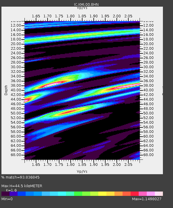
KMI Kunming, Yunnan Province, China - Earthquake Result Viewer
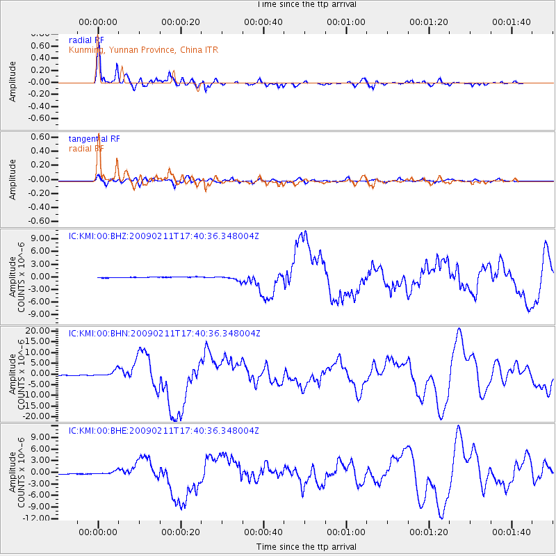
Earthquake location: Talaud Islands, Indonesia
Earthquake latitude/longitude: 3.9/126.4
Earthquake time(UTC): 2009/02/11 (042) 17:34:50 GMT
Earthquake Depth: 22 km
Earthquake Magnitude: 6.6 MB, 7.2 MS, 7.2 MW, 7.1 MW
Earthquake Catalog/Contributor: WHDF/NEIC
Network: IC New China Digital Seismograph Network
Station: KMI Kunming, Yunnan Province, China
Lat/Lon: 25.12 N/102.74 E
Elevation: 1975 m
Distance: 31.0 deg
Az: 315.131 deg
Baz: 129.059 deg
Ray Param: 0.07915967
Estimated Moho Depth: 44.5 km
Estimated Crust Vp/Vs: 1.60
Assumed Crust Vp: 6.247 km/s
Estimated Crust Vs: 3.904 km/s
Estimated Crust Poisson's Ratio: 0.18
Radial Match: 93.836845 %
Radial Bump: 400
Transverse Match: 67.23359 %
Transverse Bump: 400
SOD ConfigId: 2658
Insert Time: 2010-03-04 22:25:17.259 +0000
GWidth: 2.5
Max Bumps: 400
Tol: 0.001

Signal To Noise

ChannelStoNSTALTA
IC:KMI:00:BHN:20090211T17:40:36.348004Z12.9879651.611898E-61.2410705E-7
IC:KMI:00:BHE:20090211T17:40:36.348004Z4.33209944.6219014E-71.0668963E-7
IC:KMI:00:BHZ:20090211T17:40:36.348004Z6.94480755.8210037E-78.381807E-8
Arrivals
Ps4.6 SECOND
PpPs17 SECOND
PsPs/PpSs22 SECOND