You are here: Home > Network List > TA - USArray Transportable Network (new EarthScope stations) Stations List
> Station N59A State Game Land 141, Hazleton, PA, USA > Earthquake Result Viewer
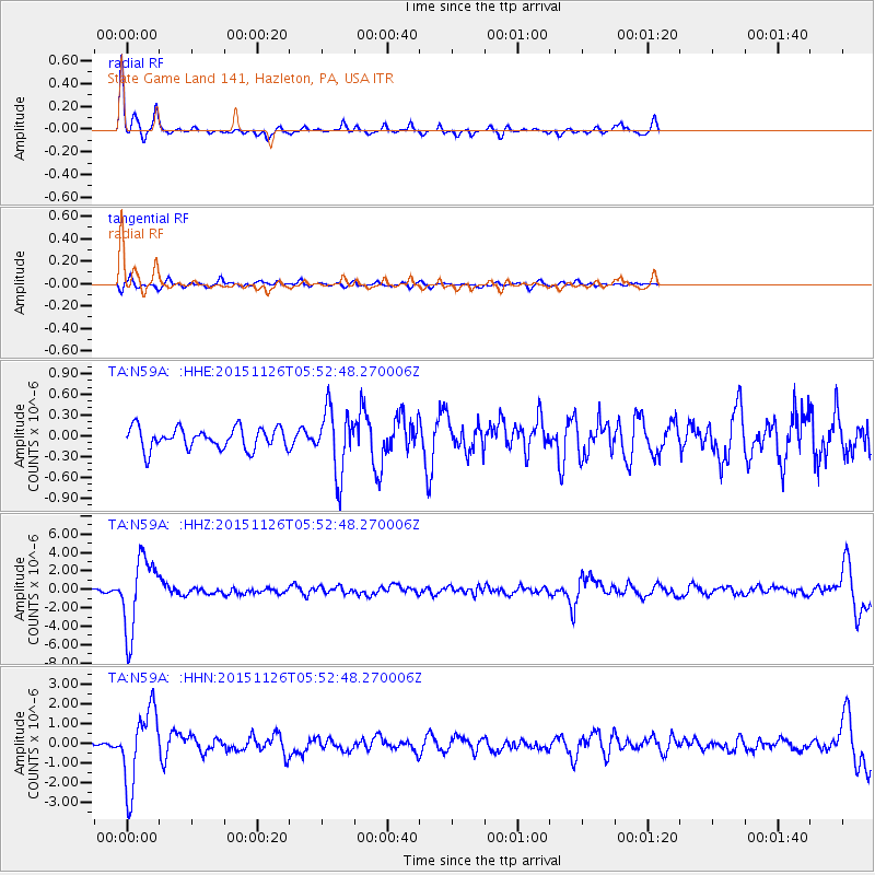
N59A State Game Land 141, Hazleton, PA, USA - Earthquake Result Viewer
| Earthquake location: |
Peru-Brazil Border Region |
| Earthquake latitude/longitude: |
-9.2/-71.3 |
| Earthquake time(UTC): |
2015/11/26 (330) 05:45:18 GMT |
| Earthquake Depth: |
604 km |
| Earthquake Magnitude: |
6.4 MWP |
| Earthquake Catalog/Contributor: |
NEIC PDE/NEIC COMCAT |
|
| Network: |
TA USArray Transportable Network (new EarthScope stations) |
| Station: |
N59A State Game Land 141, Hazleton, PA, USA |
| Lat/Lon: |
40.92 N/75.77 W |
| Elevation: |
508 m |
|
| Distance: |
50.1 deg |
| Az: |
355.553 deg |
| Baz: |
174.202 deg |
| Ray Param: |
0.06546129 |
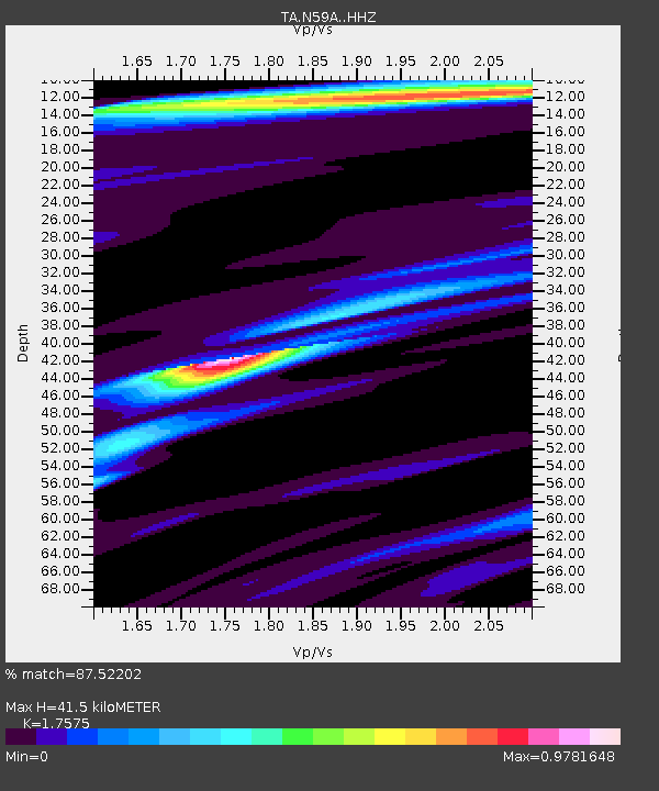
| Estimated Moho Depth: |
41.5 km |
| Estimated Crust Vp/Vs: |
1.76 |
| Assumed Crust Vp: |
6.283 km/s |
| Estimated Crust Vs: |
3.575 km/s |
| Estimated Crust Poisson's Ratio: |
0.26 |
|
| Radial Match: |
87.52202 % |
| Radial Bump: |
226 |
| Transverse Match: |
56.030746 % |
| Transverse Bump: |
400 |
| SOD ConfigId: |
7422571 |
| Insert Time: |
2019-04-21 12:10:54.633 +0000 |
| GWidth: |
2.5 |
| Max Bumps: |
400 |
| Tol: |
0.001 |
|
Signal To Noise
| Channel | StoN | STA | LTA |
| TA:N59A: :HHZ:20151126T05:52:48.270006Z | 20.872652 | 3.9393335E-6 | 1.8873183E-7 |
| TA:N59A: :HHN:20151126T05:52:48.270006Z | 14.221998 | 1.933107E-6 | 1.3592373E-7 |
| TA:N59A: :HHE:20151126T05:52:48.270006Z | 2.9729962 | 4.62209E-7 | 1.5546908E-7 |
| Arrivals |
| Ps | 5.3 SECOND |
| PpPs | 17 SECOND |
| PsPs/PpSs | 23 SECOND |


