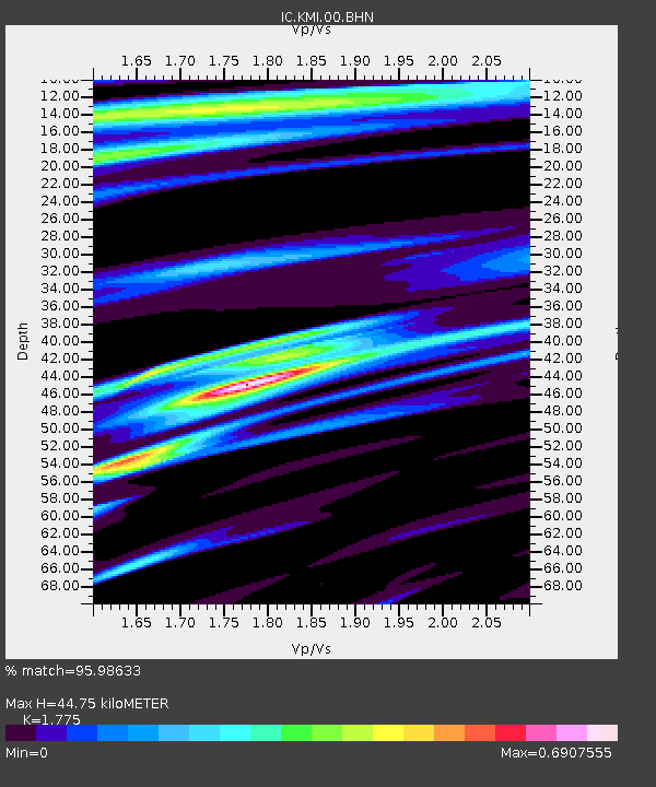
KMI Kunming, Yunnan Province, China - Earthquake Result Viewer
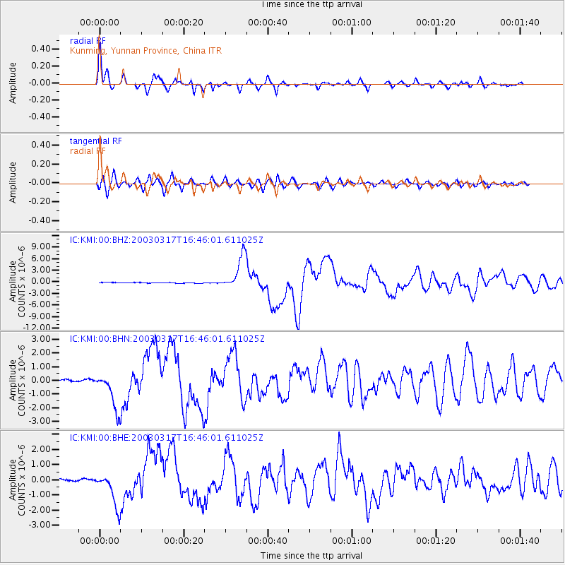
Earthquake location: Rat Islands, Aleutian Islands
Earthquake latitude/longitude: 51.3/178.0
Earthquake time(UTC): 2003/03/17 (076) 16:36:17 GMT
Earthquake Depth: 33 km
Earthquake Magnitude: 5.9 MB, 6.7 MS, 7.0 MW, 7.0 MW
Earthquake Catalog/Contributor: WHDF/NEIC
Network: IC New China Digital Seismograph Network
Station: KMI Kunming, Yunnan Province, China
Lat/Lon: 25.12 N/102.74 E
Elevation: 1975 m
Distance: 61.7 deg
Az: 275.572 deg
Baz: 43.607 deg
Ray Param: 0.060634304
Estimated Moho Depth: 44.75 km
Estimated Crust Vp/Vs: 1.77
Assumed Crust Vp: 6.247 km/s
Estimated Crust Vs: 3.519 km/s
Estimated Crust Poisson's Ratio: 0.27
Radial Match: 95.98633 %
Radial Bump: 279
Transverse Match: 89.273315 %
Transverse Bump: 400
SOD ConfigId: 4714
Insert Time: 2010-03-04 22:25:28.723 +0000
GWidth: 2.5
Max Bumps: 400
Tol: 0.001

Signal To Noise

ChannelStoNSTALTA
IC:KMI:00:BHN:20030317T16:46:01.611025Z17.687221.3978668E-67.903259E-8
IC:KMI:00:BHE:20030317T16:46:01.611025Z20.7698541.1658243E-65.6130595E-8
IC:KMI:00:BHZ:20030317T16:46:01.611025Z48.432144.5562415E-69.407474E-8
Arrivals
Ps5.8 SECOND
PpPs19 SECOND
PsPs/PpSs25 SECOND