You are here: Home > Network List > TA - USArray Transportable Network (new EarthScope stations) Stations List
> Station W39A Magazine, AR, USA > Earthquake Result Viewer
W39A Magazine, AR, USA - Earthquake Result Viewer
| Earthquake location: |
Peru-Brazil Border Region |
| Earthquake latitude/longitude: |
-9.2/-71.3 |
| Earthquake time(UTC): |
2015/11/26 (330) 05:45:18 GMT |
| Earthquake Depth: |
604 km |
| Earthquake Magnitude: |
6.4 MWP |
| Earthquake Catalog/Contributor: |
NEIC PDE/NEIC COMCAT |
|
| Network: |
TA USArray Transportable Network (new EarthScope stations) |
| Station: |
W39A Magazine, AR, USA |
| Lat/Lon: |
35.20 N/93.78 W |
| Elevation: |
162 m |
|
| Distance: |
49.0 deg |
| Az: |
335.465 deg |
| Baz: |
149.964 deg |
| Ray Param: |
0.06608386 |
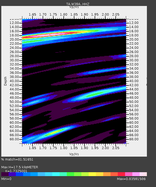
| Estimated Moho Depth: |
17.5 km |
| Estimated Crust Vp/Vs: |
1.73 |
| Assumed Crust Vp: |
6.498 km/s |
| Estimated Crust Vs: |
3.75 km/s |
| Estimated Crust Poisson's Ratio: |
0.25 |
|
| Radial Match: |
81.51651 % |
| Radial Bump: |
400 |
| Transverse Match: |
58.309753 % |
| Transverse Bump: |
400 |
| SOD ConfigId: |
7422571 |
| Insert Time: |
2019-04-21 12:11:16.437 +0000 |
| GWidth: |
2.5 |
| Max Bumps: |
400 |
| Tol: |
0.001 |
|

Signal To Noise
| Channel | StoN | STA | LTA |
| TA:W39A: :HHZ:20151126T05:52:40.860002Z | 14.52438 | 5.9250688E-6 | 4.0793952E-7 |
| TA:W39A: :HHN:20151126T05:52:40.860002Z | 7.9814076 | 2.0237906E-6 | 2.535631E-7 |
| TA:W39A: :HHE:20151126T05:52:40.860002Z | 9.444315 | 1.1700618E-6 | 1.2389059E-7 |
| Arrivals |
| Ps | 2.1 SECOND |
| PpPs | 7.0 SECOND |
| PsPs/PpSs | 9.0 SECOND |


