You are here: Home > Network List > TA - USArray Transportable Network (new EarthScope stations) Stations List
> Station Z41A Richland Creek Farm, El Dorado, AR, USA > Earthquake Result Viewer
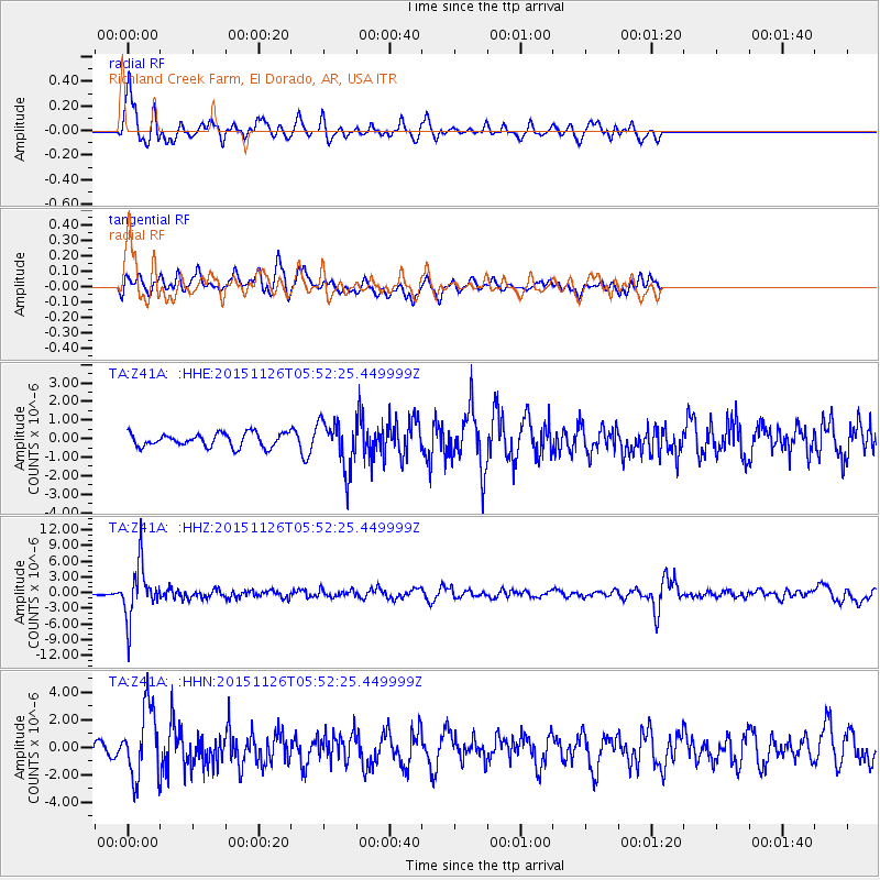
Z41A Richland Creek Farm, El Dorado, AR, USA - Earthquake Result Viewer
*The percent match for this event was below the threshold and hence no stack was calculated.
| Earthquake location: |
Peru-Brazil Border Region |
| Earthquake latitude/longitude: |
-9.2/-71.3 |
| Earthquake time(UTC): |
2015/11/26 (330) 05:45:18 GMT |
| Earthquake Depth: |
604 km |
| Earthquake Magnitude: |
6.4 MWP |
| Earthquake Catalog/Contributor: |
NEIC PDE/NEIC COMCAT |
|
| Network: |
TA USArray Transportable Network (new EarthScope stations) |
| Station: |
Z41A Richland Creek Farm, El Dorado, AR, USA |
| Lat/Lon: |
33.26 N/92.80 W |
| Elevation: |
62 m |
|
| Distance: |
47.0 deg |
| Az: |
335.117 deg |
| Baz: |
150.281 deg |
| Ray Param: |
$rayparam |
*The percent match for this event was below the threshold and hence was not used in the summary stack. |
|
| Radial Match: |
75.7262 % |
| Radial Bump: |
400 |
| Transverse Match: |
53.70494 % |
| Transverse Bump: |
400 |
| SOD ConfigId: |
7422571 |
| Insert Time: |
2019-04-21 12:11:19.861 +0000 |
| GWidth: |
2.5 |
| Max Bumps: |
400 |
| Tol: |
0.001 |
|
Signal To Noise
| Channel | StoN | STA | LTA |
| TA:Z41A: :HHZ:20151126T05:52:25.449999Z | 28.47529 | 5.0909493E-6 | 1.787848E-7 |
| TA:Z41A: :HHN:20151126T05:52:25.449999Z | 8.766697 | 2.5516001E-6 | 2.9105607E-7 |
| TA:Z41A: :HHE:20151126T05:52:25.449999Z | 3.7816365 | 1.3845142E-6 | 3.661151E-7 |
| Arrivals |
| Ps | |
| PpPs | |
| PsPs/PpSs | |


