You are here: Home > Network List > TD - TransAlta Monitoring Network Stations List
> Station TD029 Z > Earthquake Result Viewer
TD029 Z - Earthquake Result Viewer
| Earthquake location: |
Peru-Brazil Border Region |
| Earthquake latitude/longitude: |
-9.2/-71.3 |
| Earthquake time(UTC): |
2015/11/26 (330) 05:45:18 GMT |
| Earthquake Depth: |
604 km |
| Earthquake Magnitude: |
6.4 MWP |
| Earthquake Catalog/Contributor: |
NEIC PDE/NEIC COMCAT |
|
| Network: |
TD TransAlta Monitoring Network |
| Station: |
TD029 Z |
| Lat/Lon: |
52.22 N/115.20 W |
| Elevation: |
1164 m |
|
| Distance: |
71.8 deg |
| Az: |
333.305 deg |
| Baz: |
133.875 deg |
| Ray Param: |
0.05200111 |
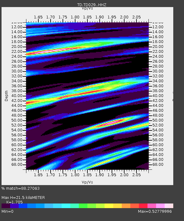
| Estimated Moho Depth: |
21.5 km |
| Estimated Crust Vp/Vs: |
1.71 |
| Assumed Crust Vp: |
6.426 km/s |
| Estimated Crust Vs: |
3.769 km/s |
| Estimated Crust Poisson's Ratio: |
0.24 |
|
| Radial Match: |
88.27063 % |
| Radial Bump: |
400 |
| Transverse Match: |
70.588394 % |
| Transverse Bump: |
400 |
| SOD ConfigId: |
7422571 |
| Insert Time: |
2019-04-21 12:11:27.079 +0000 |
| GWidth: |
2.5 |
| Max Bumps: |
400 |
| Tol: |
0.001 |
|

Signal To Noise
| Channel | StoN | STA | LTA |
| TD:TD029: :HHZ:20151126T05:55:10.19002Z | 25.572897 | 8.7413855E-6 | 3.4182224E-7 |
| TD:TD029: :HH1:20151126T05:55:10.19002Z | 2.5610914 | 6.406981E-7 | 2.5016604E-7 |
| TD:TD029: :HH2:20151126T05:55:10.19002Z | 6.7873697 | 2.4181536E-6 | 3.5627255E-7 |
| Arrivals |
| Ps | 2.4 SECOND |
| PpPs | 8.7 SECOND |
| PsPs/PpSs | 11 SECOND |


