You are here: Home > Network List > US - United States National Seismic Network Stations List
> Station DGMT Dagmar, Montana, USA > Earthquake Result Viewer
DGMT Dagmar, Montana, USA - Earthquake Result Viewer

| Earthquake location: |
Peru-Brazil Border Region |
| Earthquake latitude/longitude: |
-9.2/-71.3 |
| Earthquake time(UTC): |
2015/11/26 (330) 05:45:18 GMT |
| Earthquake Depth: |
604 km |
| Earthquake Magnitude: |
6.4 MWP |
| Earthquake Catalog/Contributor: |
NEIC PDE/NEIC COMCAT |
|
| Network: |
US United States National Seismic Network |
| Station: |
DGMT Dagmar, Montana, USA |
| Lat/Lon: |
48.47 N/104.20 W |
| Elevation: |
0.0 m |
|
| Distance: |
64.4 deg |
| Az: |
336.347 deg |
| Baz: |
143.477 deg |
| Ray Param: |
0.05668092 |
| Estimated Moho Depth: |
18.5 km |
| Estimated Crust Vp/Vs: |
1.84 |
| Assumed Crust Vp: |
6.438 km/s |
| Estimated Crust Vs: |
3.503 km/s |
| Estimated Crust Poisson's Ratio: |
0.29 |
|
| Radial Match: |
82.099915 % |
| Radial Bump: |
395 |
| Transverse Match: |
57.667244 % |
| Transverse Bump: |
400 |
| SOD ConfigId: |
7422571 |
| Insert Time: |
2019-04-21 12:11:33.026 +0000 |
| GWidth: |
2.5 |
| Max Bumps: |
400 |
| Tol: |
0.001 |
|
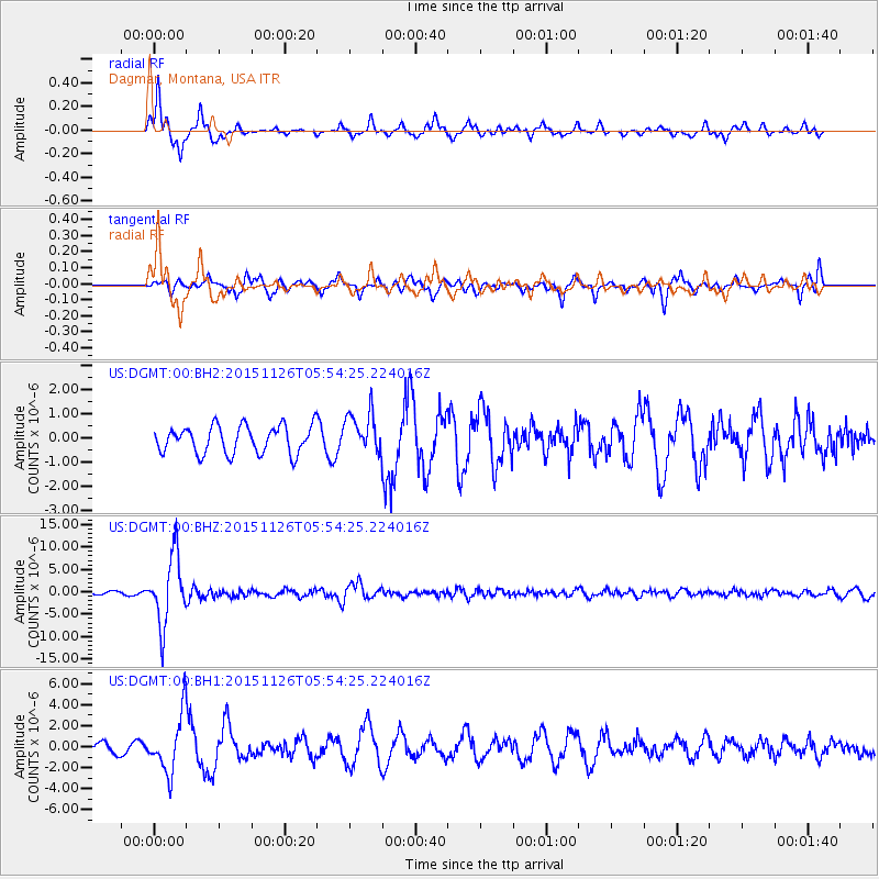
Signal To Noise
| Channel | StoN | STA | LTA |
| US:DGMT:00:BHZ:20151126T05:54:25.224016Z | 27.266077 | 7.5507132E-6 | 2.76927E-7 |
| US:DGMT:00:BH1:20151126T05:54:25.224016Z | 4.50379 | 2.8412724E-6 | 6.3086253E-7 |
| US:DGMT:00:BH2:20151126T05:54:25.224016Z | 1.852439 | 1.0807715E-6 | 5.834316E-7 |
| Arrivals |
| Ps | 2.5 SECOND |
| PpPs | 7.9 SECOND |
| PsPs/PpSs | 10 SECOND |


