You are here: Home > Network List > IC - New China Digital Seismograph Network Stations List
> Station KMI Kunming, Yunnan Province, China > Earthquake Result Viewer
KMI Kunming, Yunnan Province, China - Earthquake Result Viewer

| Earthquake location: |
Seram, Indonesia |
| Earthquake latitude/longitude: |
-3.2/127.5 |
| Earthquake time(UTC): |
2003/03/30 (089) 18:13:34 GMT |
| Earthquake Depth: |
33 km |
| Earthquake Magnitude: |
5.8 MB, 6.0 MS, 6.2 MW, 6.2 MW |
| Earthquake Catalog/Contributor: |
WHDF/NEIC |
|
| Network: |
IC New China Digital Seismograph Network |
| Station: |
KMI Kunming, Yunnan Province, China |
| Lat/Lon: |
25.12 N/102.74 E |
| Elevation: |
1975 m |
|
| Distance: |
37.0 deg |
| Az: |
320.833 deg |
| Baz: |
135.918 deg |
| Ray Param: |
0.07630371 |
| Estimated Moho Depth: |
31.75 km |
| Estimated Crust Vp/Vs: |
2.00 |
| Assumed Crust Vp: |
6.247 km/s |
| Estimated Crust Vs: |
3.119 km/s |
| Estimated Crust Poisson's Ratio: |
0.33 |
|
| Radial Match: |
92.89613 % |
| Radial Bump: |
400 |
| Transverse Match: |
81.88184 % |
| Transverse Bump: |
400 |
| SOD ConfigId: |
4714 |
| Insert Time: |
2010-03-04 22:25:37.881 +0000 |
| GWidth: |
2.5 |
| Max Bumps: |
400 |
| Tol: |
0.001 |
|
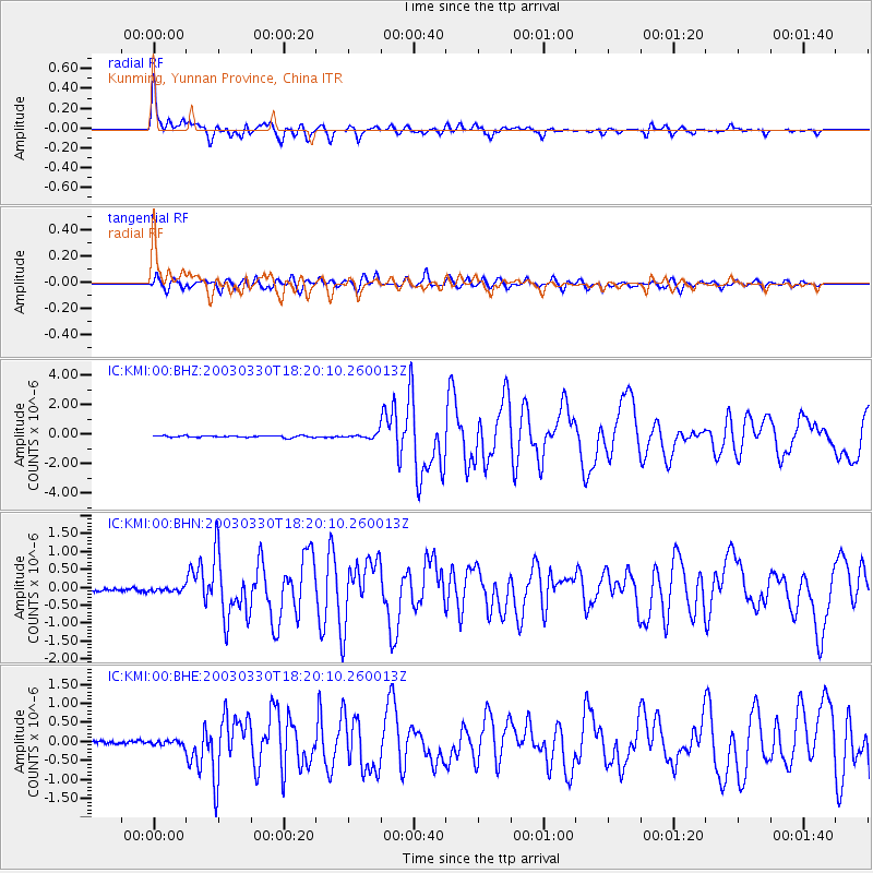
Signal To Noise
| Channel | StoN | STA | LTA |
| IC:KMI:00:BHN:20030330T18:20:10.260013Z | 1.3301057 | 5.4186074E-8 | 4.0738172E-8 |
| IC:KMI:00:BHE:20030330T18:20:10.260013Z | 1.6231151 | 6.217191E-8 | 3.8304066E-8 |
| IC:KMI:00:BHZ:20030330T18:20:10.260013Z | 2.6727092 | 1.5331081E-7 | 5.736157E-8 |
| Arrivals |
| Ps | 5.4 SECOND |
| PpPs | 14 SECOND |
| PsPs/PpSs | 20 SECOND |


