You are here: Home > Network List > BK - Berkeley Digital Seismograph Network Stations List
> Station HUMO Hull Mountain, OR > Earthquake Result Viewer
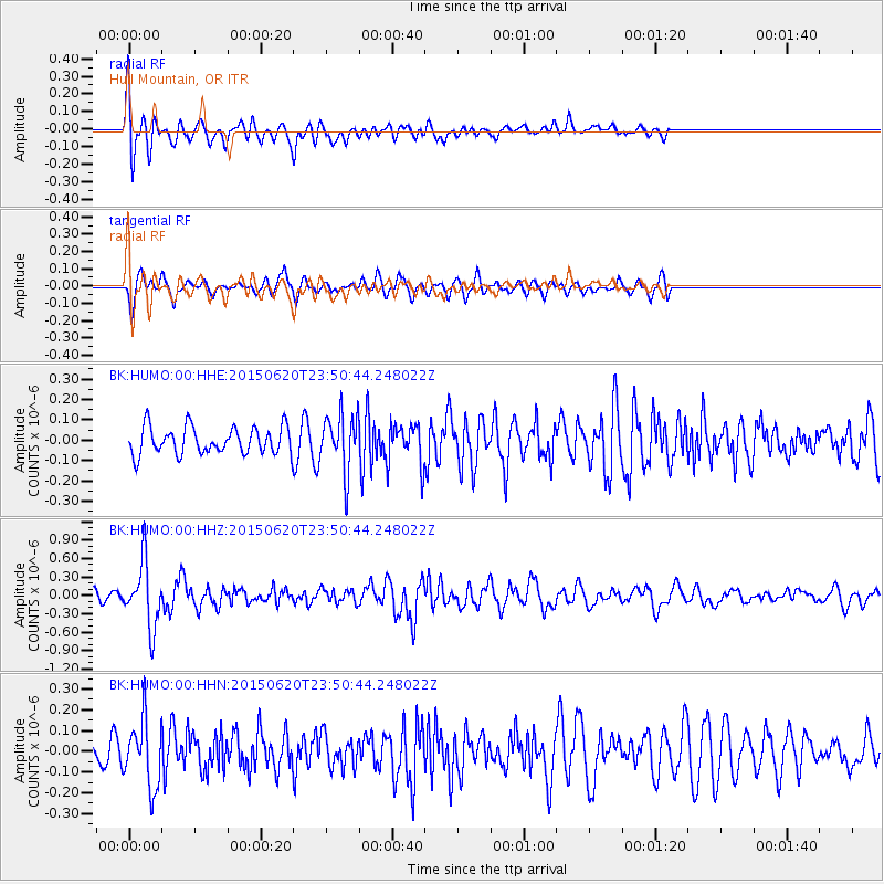
HUMO Hull Mountain, OR - Earthquake Result Viewer
*The percent match for this event was below the threshold and hence no stack was calculated.
| Earthquake location: |
South Of Fiji Islands |
| Earthquake latitude/longitude: |
-23.6/-177.1 |
| Earthquake time(UTC): |
2015/06/20 (171) 23:39:09 GMT |
| Earthquake Depth: |
158 km |
| Earthquake Magnitude: |
5.9 MO |
| Earthquake Catalog/Contributor: |
NEIC PDE/NEIC ALERT |
|
| Network: |
BK Berkeley Digital Seismograph Network |
| Station: |
HUMO Hull Mountain, OR |
| Lat/Lon: |
42.61 N/122.96 W |
| Elevation: |
555 m |
|
| Distance: |
82.6 deg |
| Az: |
37.112 deg |
| Baz: |
228.586 deg |
| Ray Param: |
$rayparam |
*The percent match for this event was below the threshold and hence was not used in the summary stack. |
|
| Radial Match: |
75.052574 % |
| Radial Bump: |
400 |
| Transverse Match: |
70.286575 % |
| Transverse Bump: |
400 |
| SOD ConfigId: |
976571 |
| Insert Time: |
2015-07-05 00:05:39.719 +0000 |
| GWidth: |
2.5 |
| Max Bumps: |
400 |
| Tol: |
0.001 |
|
Signal To Noise
| Channel | StoN | STA | LTA |
| BK:HUMO:00:HHZ:20150620T23:50:44.248022Z | 6.673688 | 5.2081157E-7 | 7.803955E-8 |
| BK:HUMO:00:HHN:20150620T23:50:44.248022Z | 3.5815969 | 1.5960944E-7 | 4.4563766E-8 |
| BK:HUMO:00:HHE:20150620T23:50:44.248022Z | 2.132039 | 1.4185657E-7 | 6.6535634E-8 |
| Arrivals |
| Ps | |
| PpPs | |
| PsPs/PpSs | |


