You are here: Home > Network List > IC - New China Digital Seismograph Network Stations List
> Station KMI Kunming, Yunnan Province, China > Earthquake Result Viewer
KMI Kunming, Yunnan Province, China - Earthquake Result Viewer
| Earthquake location: |
Solomon Islands |
| Earthquake latitude/longitude: |
-11.0/162.2 |
| Earthquake time(UTC): |
2004/10/08 (282) 08:27:53 GMT |
| Earthquake Depth: |
36 km |
| Earthquake Magnitude: |
6.1 MB, 6.9 MS, 6.8 MW, 6.8 MW |
| Earthquake Catalog/Contributor: |
WHDF/NEIC |
|
| Network: |
IC New China Digital Seismograph Network |
| Station: |
KMI Kunming, Yunnan Province, China |
| Lat/Lon: |
25.12 N/102.74 E |
| Elevation: |
1975 m |
|
| Distance: |
68.1 deg |
| Az: |
302.734 deg |
| Baz: |
114.317 deg |
| Ray Param: |
0.05647369 |
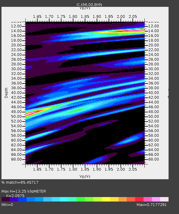
| Estimated Moho Depth: |
13.25 km |
| Estimated Crust Vp/Vs: |
2.10 |
| Assumed Crust Vp: |
6.247 km/s |
| Estimated Crust Vs: |
2.978 km/s |
| Estimated Crust Poisson's Ratio: |
0.35 |
|
| Radial Match: |
95.45717 % |
| Radial Bump: |
400 |
| Transverse Match: |
87.561676 % |
| Transverse Bump: |
400 |
| SOD ConfigId: |
2459 |
| Insert Time: |
2010-03-04 22:25:52.833 +0000 |
| GWidth: |
2.5 |
| Max Bumps: |
400 |
| Tol: |
0.001 |
|
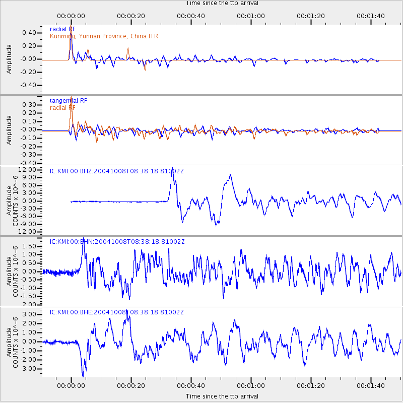
Signal To Noise
| Channel | StoN | STA | LTA |
| IC:KMI:00:BHN:20041008T08:38:18.81002Z | 8.062674 | 7.247329E-7 | 8.9887415E-8 |
| IC:KMI:00:BHE:20041008T08:38:18.81002Z | 17.312748 | 1.5226442E-6 | 8.79493E-8 |
| IC:KMI:00:BHZ:20041008T08:38:18.81002Z | 74.34877 | 5.308314E-6 | 7.139747E-8 |
| Arrivals |
| Ps | 2.4 SECOND |
| PpPs | 6.4 SECOND |
| PsPs/PpSs | 8.8 SECOND |


