You are here: Home > Network List > XD14 - Illuminating the architecture of the greater Mount St. Helens magmatic systems f Stations List
> Station MK11 "Mount St Helens, WA" > Earthquake Result Viewer
MK11 "Mount St Helens, WA" - Earthquake Result Viewer
| Earthquake location: |
Peru-Brazil Border Region |
| Earthquake latitude/longitude: |
-9.2/-71.3 |
| Earthquake time(UTC): |
2015/11/26 (330) 05:45:18 GMT |
| Earthquake Depth: |
604 km |
| Earthquake Magnitude: |
6.4 MWP |
| Earthquake Catalog/Contributor: |
NEIC PDE/NEIC COMCAT |
|
| Network: |
XD Illuminating the architecture of the greater Mount St. Helens magmatic systems f |
| Station: |
MK11 "Mount St Helens, WA" |
| Lat/Lon: |
46.15 N/121.60 W |
| Elevation: |
1343 m |
|
| Distance: |
71.1 deg |
| Az: |
325.562 deg |
| Baz: |
126.571 deg |
| Ray Param: |
0.052453015 |
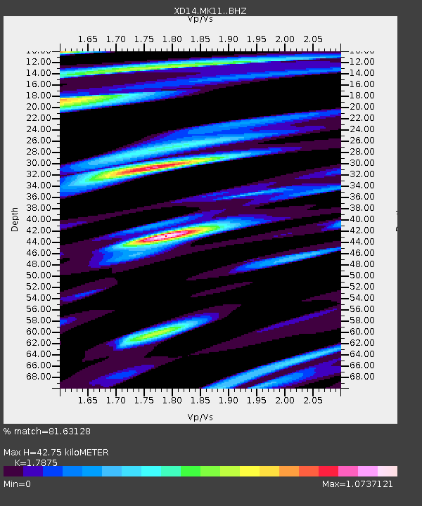
| Estimated Moho Depth: |
42.75 km |
| Estimated Crust Vp/Vs: |
1.79 |
| Assumed Crust Vp: |
6.597 km/s |
| Estimated Crust Vs: |
3.691 km/s |
| Estimated Crust Poisson's Ratio: |
0.27 |
|
| Radial Match: |
81.63128 % |
| Radial Bump: |
400 |
| Transverse Match: |
62.693817 % |
| Transverse Bump: |
400 |
| SOD ConfigId: |
7422571 |
| Insert Time: |
2019-04-21 12:13:14.235 +0000 |
| GWidth: |
2.5 |
| Max Bumps: |
400 |
| Tol: |
0.001 |
|

Signal To Noise
| Channel | StoN | STA | LTA |
| XD:MK11: :BHZ:20151126T05:55:06.120012Z | 19.116972 | 3.2738258E-6 | 1.7125232E-7 |
| XD:MK11: :BHN:20151126T05:55:06.120012Z | 3.6337805 | 7.219243E-7 | 1.9867032E-7 |
| XD:MK11: :BHE:20151126T05:55:06.120012Z | 2.9571135 | 7.2749793E-7 | 2.460162E-7 |
| Arrivals |
| Ps | 5.3 SECOND |
| PpPs | 17 SECOND |
| PsPs/PpSs | 23 SECOND |


