You are here: Home > Network List > YT07 - POLENET Stations List
> Station CLRK CLRK > Earthquake Result Viewer
CLRK CLRK - Earthquake Result Viewer
| Earthquake location: |
Peru-Brazil Border Region |
| Earthquake latitude/longitude: |
-9.2/-71.3 |
| Earthquake time(UTC): |
2015/11/26 (330) 05:45:18 GMT |
| Earthquake Depth: |
604 km |
| Earthquake Magnitude: |
6.4 MWP |
| Earthquake Catalog/Contributor: |
NEIC PDE/NEIC COMCAT |
|
| Network: |
YT POLENET |
| Station: |
CLRK CLRK |
| Lat/Lon: |
77.32 S/141.85 W |
| Elevation: |
1043 m |
|
| Distance: |
76.8 deg |
| Az: |
192.352 deg |
| Baz: |
72.982 deg |
| Ray Param: |
0.048794005 |
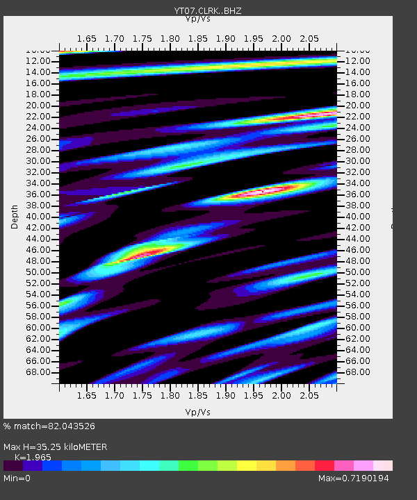
| Estimated Moho Depth: |
35.25 km |
| Estimated Crust Vp/Vs: |
1.97 |
| Assumed Crust Vp: |
6.182 km/s |
| Estimated Crust Vs: |
3.146 km/s |
| Estimated Crust Poisson's Ratio: |
0.33 |
|
| Radial Match: |
82.043526 % |
| Radial Bump: |
400 |
| Transverse Match: |
86.19967 % |
| Transverse Bump: |
400 |
| SOD ConfigId: |
7422571 |
| Insert Time: |
2019-04-21 12:14:00.455 +0000 |
| GWidth: |
2.5 |
| Max Bumps: |
400 |
| Tol: |
0.001 |
|

Signal To Noise
| Channel | StoN | STA | LTA |
| YT:CLRK: :BHZ:20151126T05:55:38.573992Z | 28.452187 | 3.3049168E-6 | 1.1615687E-7 |
| YT:CLRK: :BHN:20151126T05:55:38.573992Z | 6.358978 | 5.592202E-7 | 8.794184E-8 |
| YT:CLRK: :BHE:20151126T05:55:38.573992Z | 10.062082 | 1.0783923E-6 | 1.0717387E-7 |
| Arrivals |
| Ps | 5.6 SECOND |
| PpPs | 17 SECOND |
| PsPs/PpSs | 22 SECOND |


