You are here: Home > Network List > YT07 - POLENET Stations List
> Station RMBO RMBO > Earthquake Result Viewer
RMBO RMBO - Earthquake Result Viewer
| Earthquake location: |
Peru-Brazil Border Region |
| Earthquake latitude/longitude: |
-9.2/-71.3 |
| Earthquake time(UTC): |
2015/11/26 (330) 05:45:18 GMT |
| Earthquake Depth: |
604 km |
| Earthquake Magnitude: |
6.4 MWP |
| Earthquake Catalog/Contributor: |
NEIC PDE/NEIC COMCAT |
|
| Network: |
YT POLENET |
| Station: |
RMBO RMBO |
| Lat/Lon: |
83.87 S/66.40 W |
| Elevation: |
800 m |
|
| Distance: |
74.7 deg |
| Az: |
179.457 deg |
| Baz: |
355.01 deg |
| Ray Param: |
0.050181802 |
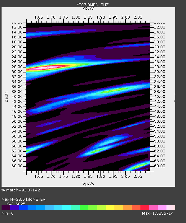
| Estimated Moho Depth: |
28.0 km |
| Estimated Crust Vp/Vs: |
1.68 |
| Assumed Crust Vp: |
6.356 km/s |
| Estimated Crust Vs: |
3.778 km/s |
| Estimated Crust Poisson's Ratio: |
0.23 |
|
| Radial Match: |
93.87142 % |
| Radial Bump: |
400 |
| Transverse Match: |
90.36871 % |
| Transverse Bump: |
400 |
| SOD ConfigId: |
7422571 |
| Insert Time: |
2019-04-21 12:14:19.253 +0000 |
| GWidth: |
2.5 |
| Max Bumps: |
400 |
| Tol: |
0.001 |
|

Signal To Noise
| Channel | StoN | STA | LTA |
| YT:RMBO: :BHZ:20151126T05:55:26.823992Z | 30.793129 | 3.9692045E-6 | 1.2889903E-7 |
| YT:RMBO: :BHN:20151126T05:55:26.823992Z | 20.122889 | 1.8890566E-6 | 9.387602E-8 |
| YT:RMBO: :BHE:20151126T05:55:26.823992Z | 4.536122 | 4.3940773E-7 | 9.686858E-8 |
| Arrivals |
| Ps | 3.1 SECOND |
| PpPs | 11 SECOND |
| PsPs/PpSs | 15 SECOND |


