You are here: Home > Network List > IC - New China Digital Seismograph Network Stations List
> Station KMI Kunming, Yunnan Province, China > Earthquake Result Viewer
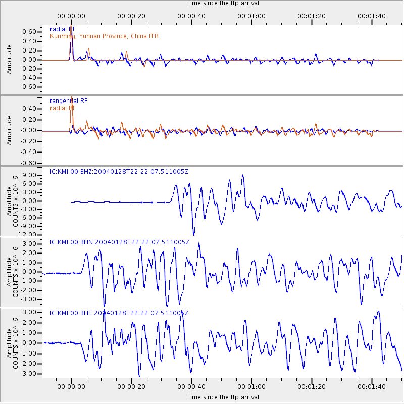
KMI Kunming, Yunnan Province, China - Earthquake Result Viewer

| Earthquake location: |
Seram, Indonesia |
| Earthquake latitude/longitude: |
-3.1/127.4 |
| Earthquake time(UTC): |
2004/01/28 (028) 22:15:30 GMT |
| Earthquake Depth: |
17 km |
| Earthquake Magnitude: |
6.0 MB, 6.5 MS, 6.7 MW, 6.6 MW |
| Earthquake Catalog/Contributor: |
WHDF/NEIC |
|
| Network: |
IC New China Digital Seismograph Network |
| Station: |
KMI Kunming, Yunnan Province, China |
| Lat/Lon: |
25.12 N/102.74 E |
| Elevation: |
1975 m |
|
| Distance: |
36.9 deg |
| Az: |
320.946 deg |
| Baz: |
136.05 deg |
| Ray Param: |
0.07641604 |
| Estimated Moho Depth: |
33.75 km |
| Estimated Crust Vp/Vs: |
1.88 |
| Assumed Crust Vp: |
6.247 km/s |
| Estimated Crust Vs: |
3.314 km/s |
| Estimated Crust Poisson's Ratio: |
0.30 |
|
| Radial Match: |
93.204285 % |
| Radial Bump: |
400 |
| Transverse Match: |
83.80457 % |
| Transverse Bump: |
400 |
| SOD ConfigId: |
2459 |
| Insert Time: |
2010-03-04 22:26:24.262 +0000 |
| GWidth: |
2.5 |
| Max Bumps: |
400 |
| Tol: |
0.001 |
|
Signal To Noise
| Channel | StoN | STA | LTA |
| IC:KMI:00:BHN:20040128T22:22:07.511005Z | 12.150671 | 6.2042034E-7 | 5.106058E-8 |
| IC:KMI:00:BHE:20040128T22:22:07.511005Z | 10.714303 | 5.787844E-7 | 5.401979E-8 |
| IC:KMI:00:BHZ:20040128T22:22:07.511005Z | 28.846077 | 2.0289697E-6 | 7.03378E-8 |
| Arrivals |
| Ps | 5.1 SECOND |
| PpPs | 15 SECOND |
| PsPs/PpSs | 20 SECOND |


