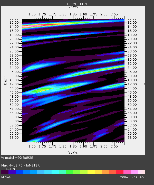
KMI Kunming, Yunnan Province, China - Earthquake Result Viewer
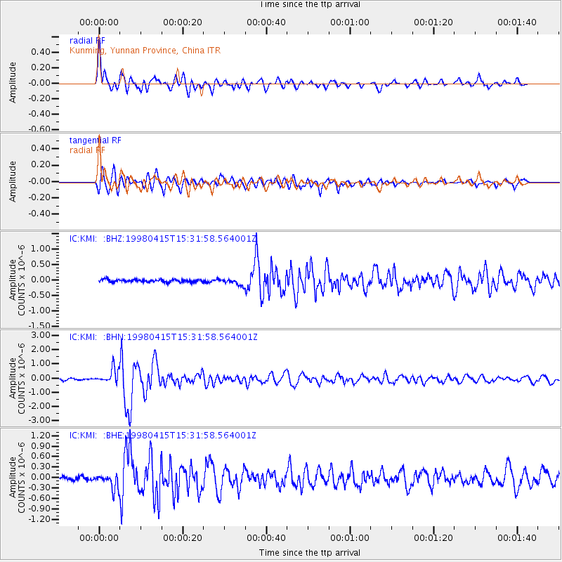
Earthquake location: Kamchatka Peninsula, Russia
Earthquake latitude/longitude: 58.5/164.4
Earthquake time(UTC): 1998/04/15 (105) 15:23:06 GMT
Earthquake Depth: 33 km
Earthquake Magnitude: 5.6 MB, 5.5 MS, 6.0 UNKNOWN, 5.9 MW
Earthquake Catalog/Contributor: WHDF/NEIC
Network: IC New China Digital Seismograph Network
Station: KMI Kunming, Yunnan Province, China
Lat/Lon: 25.12 N/102.74 E
Elevation: 1975 m
Distance: 54.2 deg
Az: 259.777 deg
Baz: 34.749 deg
Ray Param: 0.06553681
Estimated Moho Depth: 13.75 km
Estimated Crust Vp/Vs: 1.61
Assumed Crust Vp: 6.247 km/s
Estimated Crust Vs: 3.88 km/s
Estimated Crust Poisson's Ratio: 0.19
Radial Match: 92.86938 %
Radial Bump: 400
Transverse Match: 88.40984 %
Transverse Bump: 400
SOD ConfigId: 4480
Insert Time: 2010-03-04 22:26:56.895 +0000
GWidth: 2.5
Max Bumps: 400
Tol: 0.001

Signal To Noise

ChannelStoNSTALTA
IC:KMI: :BHN:19980415T15:31:58.564001Z8.5895735.1767074E-76.026734E-8
IC:KMI: :BHE:19980415T15:31:58.564001Z5.53211072.2265405E-74.0247578E-8
IC:KMI: :BHZ:19980415T15:31:58.564001Z2.6178471.09036165E-74.1651088E-8
Arrivals
Ps1.4 SECOND
PpPs5.4 SECOND
PsPs/PpSs6.9 SECOND