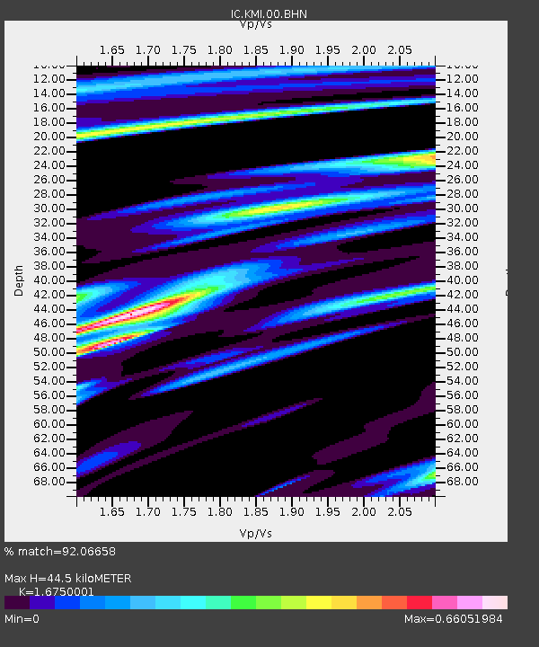
KMI Kunming, Yunnan Province, China - Earthquake Result Viewer
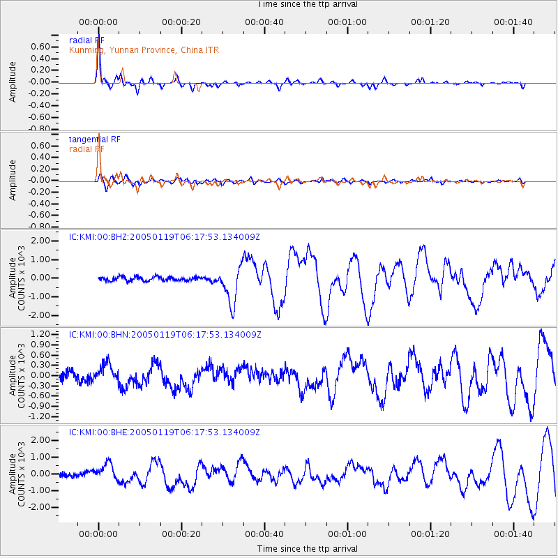
Earthquake location: Off East Coast Of Honshu, Japan
Earthquake latitude/longitude: 34.1/141.5
Earthquake time(UTC): 2005/01/19 (019) 06:11:36 GMT
Earthquake Depth: 28 km
Earthquake Magnitude: 5.8 MB, 6.4 MS, 6.5 MW, 6.4 MW
Earthquake Catalog/Contributor: WHDF/NEIC
Network: IC New China Digital Seismograph Network
Station: KMI Kunming, Yunnan Province, China
Lat/Lon: 25.12 N/102.74 E
Elevation: 1975 m
Distance: 34.7 deg
Az: 265.603 deg
Baz: 65.937 deg
Ray Param: 0.07756854
Estimated Moho Depth: 44.5 km
Estimated Crust Vp/Vs: 1.68
Assumed Crust Vp: 6.247 km/s
Estimated Crust Vs: 3.729 km/s
Estimated Crust Poisson's Ratio: 0.22
Radial Match: 92.06658 %
Radial Bump: 350
Transverse Match: 64.80641 %
Transverse Bump: 400
SOD ConfigId: 39739
Insert Time: 2010-03-04 22:27:28.894 +0000
GWidth: 2.5
Max Bumps: 400
Tol: 0.001

Signal To Noise

ChannelStoNSTALTA
IC:KMI:00:BHN:20050119T06:17:53.134009Z2.006191271.15292135.15808
IC:KMI:00:BHE:20050119T06:17:53.134009Z4.0460114550.82745136.14084
IC:KMI:00:BHZ:20050119T06:17:53.134009Z9.7993441037.1141105.83506
Arrivals
Ps5.2 SECOND
PpPs18 SECOND
PsPs/PpSs23 SECOND