You are here: Home > Network List > US - United States National Seismic Network Stations List
> Station AMTX Amarillo, Texas, USA > Earthquake Result Viewer
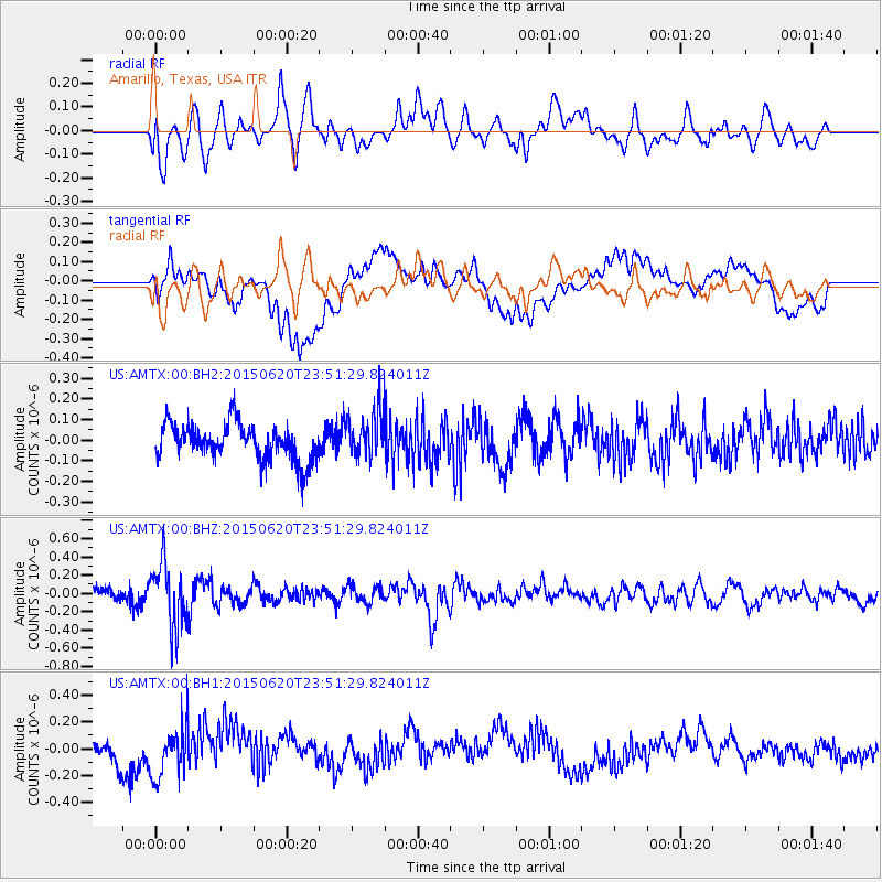
AMTX Amarillo, Texas, USA - Earthquake Result Viewer
*The percent match for this event was below the threshold and hence no stack was calculated.
| Earthquake location: |
South Of Fiji Islands |
| Earthquake latitude/longitude: |
-23.6/-177.1 |
| Earthquake time(UTC): |
2015/06/20 (171) 23:39:09 GMT |
| Earthquake Depth: |
158 km |
| Earthquake Magnitude: |
5.9 MO |
| Earthquake Catalog/Contributor: |
NEIC PDE/NEIC ALERT |
|
| Network: |
US United States National Seismic Network |
| Station: |
AMTX Amarillo, Texas, USA |
| Lat/Lon: |
34.53 N/101.41 W |
| Elevation: |
1010 m |
|
| Distance: |
92.1 deg |
| Az: |
53.182 deg |
| Baz: |
242.843 deg |
| Ray Param: |
$rayparam |
*The percent match for this event was below the threshold and hence was not used in the summary stack. |
|
| Radial Match: |
41.752426 % |
| Radial Bump: |
400 |
| Transverse Match: |
41.222065 % |
| Transverse Bump: |
400 |
| SOD ConfigId: |
976571 |
| Insert Time: |
2015-07-05 00:10:21.094 +0000 |
| GWidth: |
2.5 |
| Max Bumps: |
400 |
| Tol: |
0.001 |
|
Signal To Noise
| Channel | StoN | STA | LTA |
| US:AMTX:00:BHZ:20150620T23:51:29.824011Z | 4.6348066 | 3.5910958E-7 | 7.748103E-8 |
| US:AMTX:00:BH1:20150620T23:51:29.824011Z | 1.1838064 | 2.011851E-7 | 1.6994764E-7 |
| US:AMTX:00:BH2:20150620T23:51:29.824011Z | 1.3130437 | 1.1581366E-7 | 8.820245E-8 |
| Arrivals |
| Ps | |
| PpPs | |
| PsPs/PpSs | |


