You are here: Home > Network List > IC - New China Digital Seismograph Network Stations List
> Station KMI Kunming, Yunnan Province, China > Earthquake Result Viewer
KMI Kunming, Yunnan Province, China - Earthquake Result Viewer

| Earthquake location: |
Southern Iran |
| Earthquake latitude/longitude: |
27.1/61.9 |
| Earthquake time(UTC): |
2005/03/13 (072) 03:31:23 GMT |
| Earthquake Depth: |
54 km |
| Earthquake Magnitude: |
5.9 MB, 5.4 MS, 6.0 MW, 6.0 MW |
| Earthquake Catalog/Contributor: |
WHDF/NEIC |
|
| Network: |
IC New China Digital Seismograph Network |
| Station: |
KMI Kunming, Yunnan Province, China |
| Lat/Lon: |
25.12 N/102.74 E |
| Elevation: |
1975 m |
|
| Distance: |
36.6 deg |
| Az: |
83.697 deg |
| Baz: |
282.222 deg |
| Ray Param: |
0.07644059 |
| Estimated Moho Depth: |
28.75 km |
| Estimated Crust Vp/Vs: |
1.99 |
| Assumed Crust Vp: |
6.247 km/s |
| Estimated Crust Vs: |
3.139 km/s |
| Estimated Crust Poisson's Ratio: |
0.33 |
|
| Radial Match: |
92.368614 % |
| Radial Bump: |
400 |
| Transverse Match: |
84.53952 % |
| Transverse Bump: |
400 |
| SOD ConfigId: |
2455 |
| Insert Time: |
2010-03-04 22:27:53.576 +0000 |
| GWidth: |
2.5 |
| Max Bumps: |
400 |
| Tol: |
0.001 |
|
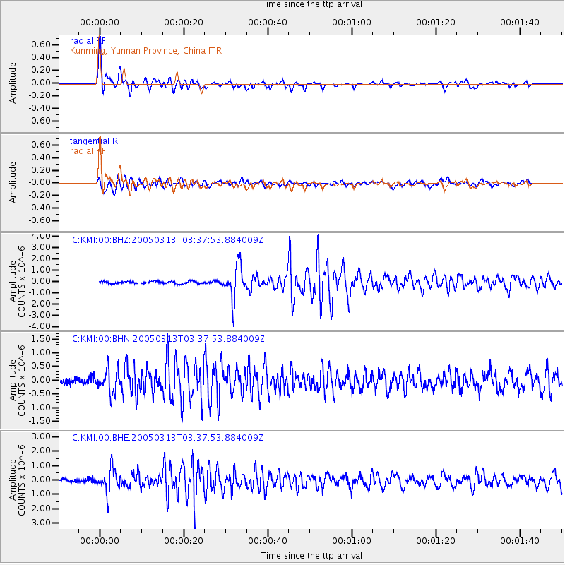
Signal To Noise
| Channel | StoN | STA | LTA |
| IC:KMI:00:BHN:20050313T03:37:53.884009Z | 4.220535 | 4.2637873E-7 | 1.0102481E-7 |
| IC:KMI:00:BHE:20050313T03:37:53.884009Z | 7.439361 | 8.311577E-7 | 1.1172435E-7 |
| IC:KMI:00:BHZ:20050313T03:37:53.884009Z | 15.238619 | 1.4920905E-6 | 9.7915084E-8 |
| Arrivals |
| Ps | 4.8 SECOND |
| PpPs | 13 SECOND |
| PsPs/PpSs | 18 SECOND |


