You are here: Home > Network List > NN - Western Great Basin/Eastern Sierra Nevada Stations List
> Station VCN Virginia City, Nevada gps > Earthquake Result Viewer
VCN Virginia City, Nevada gps - Earthquake Result Viewer
| Earthquake location: |
Near Coast Of Northern Chile |
| Earthquake latitude/longitude: |
-24.8/-70.6 |
| Earthquake time(UTC): |
2015/11/27 (331) 21:00:22 GMT |
| Earthquake Depth: |
35 km |
| Earthquake Magnitude: |
6.2 MWW, 6.2 MWB |
| Earthquake Catalog/Contributor: |
NEIC PDE/NEIC COMCAT |
|
| Network: |
NN Western Great Basin/Eastern Sierra Nevada |
| Station: |
VCN Virginia City, Nevada gps |
| Lat/Lon: |
39.30 N/119.65 W |
| Elevation: |
1928 m |
|
| Distance: |
78.5 deg |
| Az: |
323.29 deg |
| Baz: |
135.571 deg |
| Ray Param: |
0.04954077 |
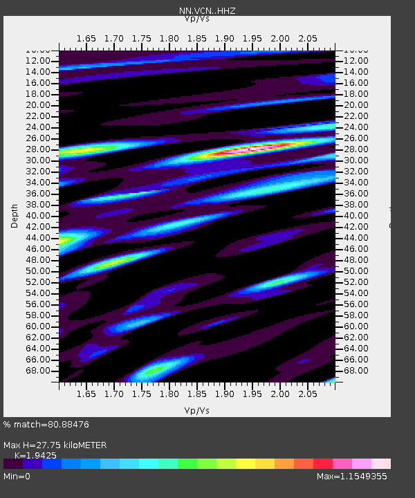
| Estimated Moho Depth: |
27.75 km |
| Estimated Crust Vp/Vs: |
1.94 |
| Assumed Crust Vp: |
6.279 km/s |
| Estimated Crust Vs: |
3.232 km/s |
| Estimated Crust Poisson's Ratio: |
0.32 |
|
| Radial Match: |
80.88476 % |
| Radial Bump: |
400 |
| Transverse Match: |
64.33659 % |
| Transverse Bump: |
400 |
| SOD ConfigId: |
7422571 |
| Insert Time: |
2019-04-21 12:27:09.896 +0000 |
| GWidth: |
2.5 |
| Max Bumps: |
400 |
| Tol: |
0.001 |
|

Signal To Noise
| Channel | StoN | STA | LTA |
| NN:VCN: :HHZ:20151127T21:11:49.765022Z | 2.2353587 | 4.2600172E-7 | 1.9057421E-7 |
| NN:VCN: :HHN:20151127T21:11:49.765022Z | 0.76316047 | 1.3040656E-7 | 1.7087699E-7 |
| NN:VCN: :HHE:20151127T21:11:49.765022Z | 0.85432696 | 2.1657128E-7 | 2.5349928E-7 |
| Arrivals |
| Ps | 4.3 SECOND |
| PpPs | 13 SECOND |
| PsPs/PpSs | 17 SECOND |


