You are here: Home > Network List > IC - New China Digital Seismograph Network Stations List
> Station KMI Kunming, Yunnan Province, China > Earthquake Result Viewer
KMI Kunming, Yunnan Province, China - Earthquake Result Viewer
| Earthquake location: |
Macquarie Island Region |
| Earthquake latitude/longitude: |
-55.7/158.5 |
| Earthquake time(UTC): |
2008/04/12 (103) 00:30:12 GMT |
| Earthquake Depth: |
16 km |
| Earthquake Magnitude: |
6.8 MB, 7.1 MS, 7.1 MW, 7.1 MW |
| Earthquake Catalog/Contributor: |
WHDF/NEIC |
|
| Network: |
IC New China Digital Seismograph Network |
| Station: |
KMI Kunming, Yunnan Province, China |
| Lat/Lon: |
25.12 N/102.74 E |
| Elevation: |
1975 m |
|
| Distance: |
93.4 deg |
| Az: |
311.388 deg |
| Baz: |
152.033 deg |
| Ray Param: |
0.041274123 |
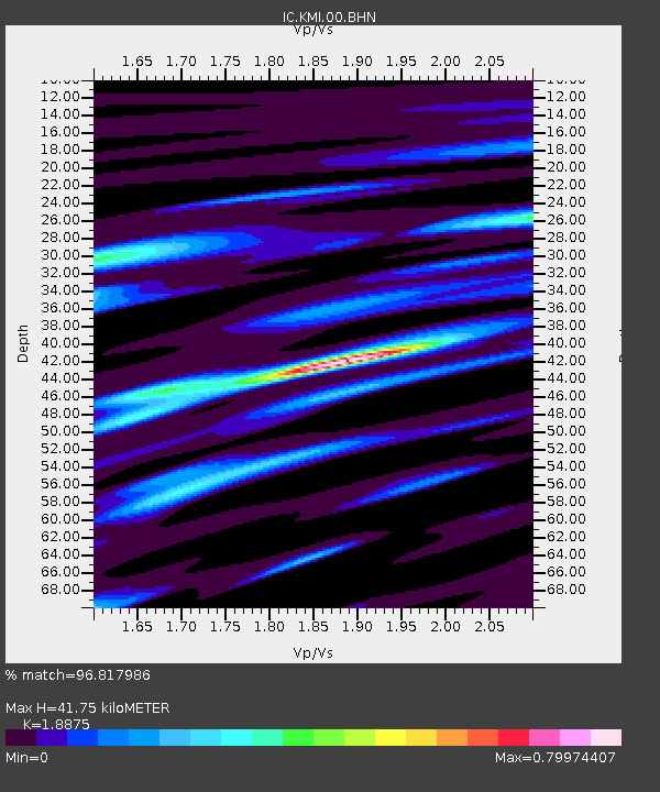
| Estimated Moho Depth: |
41.75 km |
| Estimated Crust Vp/Vs: |
1.89 |
| Assumed Crust Vp: |
6.247 km/s |
| Estimated Crust Vs: |
3.309 km/s |
| Estimated Crust Poisson's Ratio: |
0.30 |
|
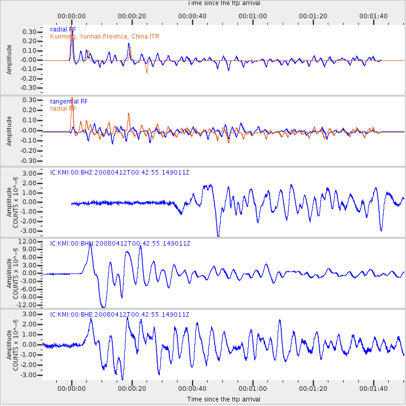
| Radial Match: |
96.817986 % |
| Radial Bump: |
318 |
| Transverse Match: |
93.45127 % |
| Transverse Bump: |
400 |
| SOD ConfigId: |
2504 |
| Insert Time: |
2010-03-04 22:28:10.633 +0000 |
| GWidth: |
2.5 |
| Max Bumps: |
400 |
| Tol: |
0.001 |
|
Signal To Noise
| Channel | StoN | STA | LTA |
| IC:KMI:00:BHN:20080412T00:42:55.149011Z | 16.336578 | 1.3631462E-6 | 8.344136E-8 |
| IC:KMI:00:BHE:20080412T00:42:55.149011Z | 2.4933155 | 2.6257044E-7 | 1.0530975E-7 |
| IC:KMI:00:BHZ:20080412T00:42:55.149011Z | 1.7900741 | 1.4216832E-7 | 7.942035E-8 |
| Arrivals |
| Ps | 6.0 SECOND |
| PpPs | 19 SECOND |
| PsPs/PpSs | 25 SECOND |


