You are here: Home > Network List > TA - USArray Transportable Network (new EarthScope stations) Stations List
> Station A04D Lummi Island, WA, USA > Earthquake Result Viewer
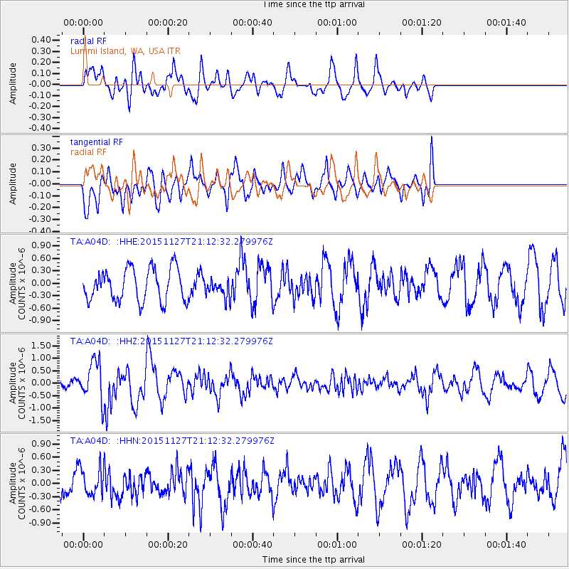
A04D Lummi Island, WA, USA - Earthquake Result Viewer
*The percent match for this event was below the threshold and hence no stack was calculated.
| Earthquake location: |
Near Coast Of Northern Chile |
| Earthquake latitude/longitude: |
-24.8/-70.6 |
| Earthquake time(UTC): |
2015/11/27 (331) 21:00:22 GMT |
| Earthquake Depth: |
35 km |
| Earthquake Magnitude: |
6.2 MWW, 6.2 MWB |
| Earthquake Catalog/Contributor: |
NEIC PDE/NEIC COMCAT |
|
| Network: |
TA USArray Transportable Network (new EarthScope stations) |
| Station: |
A04D Lummi Island, WA, USA |
| Lat/Lon: |
48.72 N/122.71 W |
| Elevation: |
13 m |
|
| Distance: |
86.7 deg |
| Az: |
328.451 deg |
| Baz: |
134.112 deg |
| Ray Param: |
$rayparam |
*The percent match for this event was below the threshold and hence was not used in the summary stack. |
|
| Radial Match: |
56.92168 % |
| Radial Bump: |
400 |
| Transverse Match: |
59.06503 % |
| Transverse Bump: |
400 |
| SOD ConfigId: |
7422571 |
| Insert Time: |
2019-04-21 12:29:07.050 +0000 |
| GWidth: |
2.5 |
| Max Bumps: |
400 |
| Tol: |
0.001 |
|
Signal To Noise
| Channel | StoN | STA | LTA |
| TA:A04D: :HHZ:20151127T21:12:32.279976Z | 3.9744189 | 8.00005E-7 | 2.0128854E-7 |
| TA:A04D: :HHN:20151127T21:12:32.279976Z | 0.76210934 | 3.0837458E-7 | 4.0463297E-7 |
| TA:A04D: :HHE:20151127T21:12:32.279976Z | 0.4973001 | 1.9323627E-7 | 3.8857075E-7 |
| Arrivals |
| Ps | |
| PpPs | |
| PsPs/PpSs | |


