You are here: Home > Network List > TA - USArray Transportable Network (new EarthScope stations) Stations List
> Station O03E Paynes Creek, CA, USA > Earthquake Result Viewer
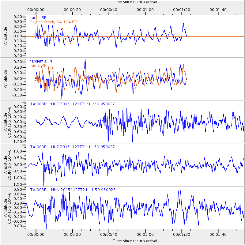
O03E Paynes Creek, CA, USA - Earthquake Result Viewer
*The percent match for this event was below the threshold and hence no stack was calculated.
| Earthquake location: |
Near Coast Of Northern Chile |
| Earthquake latitude/longitude: |
-24.8/-70.6 |
| Earthquake time(UTC): |
2015/11/27 (331) 21:00:22 GMT |
| Earthquake Depth: |
35 km |
| Earthquake Magnitude: |
6.2 MWW, 6.2 MWB |
| Earthquake Catalog/Contributor: |
NEIC PDE/NEIC COMCAT |
|
| Network: |
TA USArray Transportable Network (new EarthScope stations) |
| Station: |
O03E Paynes Creek, CA, USA |
| Lat/Lon: |
40.29 N/121.80 W |
| Elevation: |
967 m |
|
| Distance: |
80.4 deg |
| Az: |
322.82 deg |
| Baz: |
134.113 deg |
| Ray Param: |
$rayparam |
*The percent match for this event was below the threshold and hence was not used in the summary stack. |
|
| Radial Match: |
56.79898 % |
| Radial Bump: |
400 |
| Transverse Match: |
57.30042 % |
| Transverse Bump: |
400 |
| SOD ConfigId: |
7422571 |
| Insert Time: |
2019-04-21 12:29:33.970 +0000 |
| GWidth: |
2.5 |
| Max Bumps: |
400 |
| Tol: |
0.001 |
|
Signal To Noise
| Channel | StoN | STA | LTA |
| TA:O03E: :HHZ:20151127T21:11:59.95002Z | 2.7292202 | 5.231677E-7 | 1.916913E-7 |
| TA:O03E: :HHN:20151127T21:11:59.95002Z | 1.8665944 | 2.3116125E-7 | 1.2384118E-7 |
| TA:O03E: :HHE:20151127T21:11:59.95002Z | 0.8606284 | 1.4448798E-7 | 1.678866E-7 |
| Arrivals |
| Ps | |
| PpPs | |
| PsPs/PpSs | |


