You are here: Home > Network List > US - United States National Seismic Network Stations List
> Station DGMT Dagmar, Montana, USA > Earthquake Result Viewer
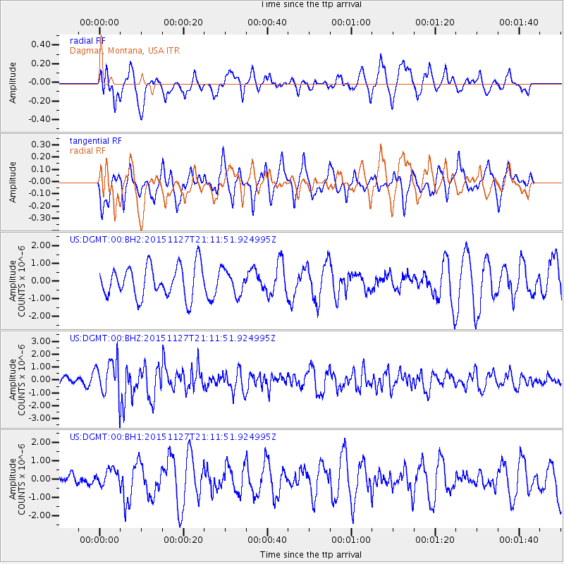
DGMT Dagmar, Montana, USA - Earthquake Result Viewer
*The percent match for this event was below the threshold and hence no stack was calculated.
| Earthquake location: |
Near Coast Of Northern Chile |
| Earthquake latitude/longitude: |
-24.8/-70.6 |
| Earthquake time(UTC): |
2015/11/27 (331) 21:00:22 GMT |
| Earthquake Depth: |
35 km |
| Earthquake Magnitude: |
6.2 MWW, 6.2 MWB |
| Earthquake Catalog/Contributor: |
NEIC PDE/NEIC COMCAT |
|
| Network: |
US United States National Seismic Network |
| Station: |
DGMT Dagmar, Montana, USA |
| Lat/Lon: |
48.47 N/104.20 W |
| Elevation: |
0.0 m |
|
| Distance: |
78.9 deg |
| Az: |
337.98 deg |
| Baz: |
149.206 deg |
| Ray Param: |
$rayparam |
*The percent match for this event was below the threshold and hence was not used in the summary stack. |
|
| Radial Match: |
57.11184 % |
| Radial Bump: |
400 |
| Transverse Match: |
54.67769 % |
| Transverse Bump: |
400 |
| SOD ConfigId: |
7422571 |
| Insert Time: |
2019-04-21 12:30:04.717 +0000 |
| GWidth: |
2.5 |
| Max Bumps: |
400 |
| Tol: |
0.001 |
|
Signal To Noise
| Channel | StoN | STA | LTA |
| US:DGMT:00:BHZ:20151127T21:11:51.924995Z | 6.0459113 | 1.4468759E-6 | 2.3931477E-7 |
| US:DGMT:00:BH1:20151127T21:11:51.924995Z | 0.68131274 | 4.5988338E-7 | 6.74996E-7 |
| US:DGMT:00:BH2:20151127T21:11:51.924995Z | 0.79511136 | 7.1047845E-7 | 8.935584E-7 |
| Arrivals |
| Ps | |
| PpPs | |
| PsPs/PpSs | |


