You are here: Home > Network List > IC - New China Digital Seismograph Network Stations List
> Station KMI Kunming, Yunnan Province, China > Earthquake Result Viewer
KMI Kunming, Yunnan Province, China - Earthquake Result Viewer
| Earthquake location: |
Pakistan |
| Earthquake latitude/longitude: |
30.6/67.4 |
| Earthquake time(UTC): |
2008/10/28 (302) 23:09:57 GMT |
| Earthquake Depth: |
15 km |
| Earthquake Magnitude: |
6.3 MB, 6.6 MS, 6.4 MW, 6.4 MW |
| Earthquake Catalog/Contributor: |
WHDF/NEIC |
|
| Network: |
IC New China Digital Seismograph Network |
| Station: |
KMI Kunming, Yunnan Province, China |
| Lat/Lon: |
25.12 N/102.74 E |
| Elevation: |
1975 m |
|
| Distance: |
31.7 deg |
| Az: |
91.181 deg |
| Baz: |
288.084 deg |
| Ray Param: |
0.07896688 |
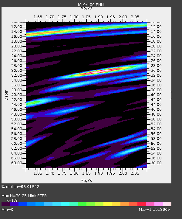
| Estimated Moho Depth: |
30.25 km |
| Estimated Crust Vp/Vs: |
1.90 |
| Assumed Crust Vp: |
6.247 km/s |
| Estimated Crust Vs: |
3.288 km/s |
| Estimated Crust Poisson's Ratio: |
0.31 |
|
| Radial Match: |
93.01842 % |
| Radial Bump: |
400 |
| Transverse Match: |
82.401115 % |
| Transverse Bump: |
400 |
| SOD ConfigId: |
2658 |
| Insert Time: |
2010-03-04 22:29:15.356 +0000 |
| GWidth: |
2.5 |
| Max Bumps: |
400 |
| Tol: |
0.001 |
|
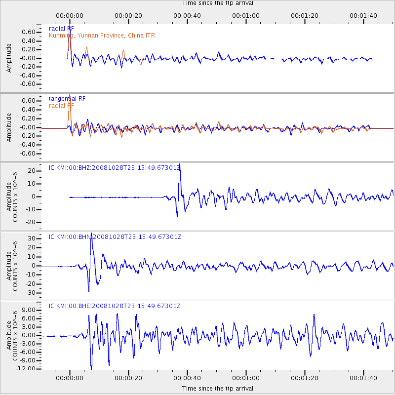
Signal To Noise
| Channel | StoN | STA | LTA |
| IC:KMI:00:BHN:20081028T23:15:49.67301Z | 19.00148 | 1.2331612E-6 | 6.489817E-8 |
| IC:KMI:00:BHE:20081028T23:15:49.67301Z | 4.331958 | 3.630462E-7 | 8.38065E-8 |
| IC:KMI:00:BHZ:20081028T23:15:49.67301Z | 9.192652 | 6.668771E-7 | 7.254459E-8 |
| Arrivals |
| Ps | 4.7 SECOND |
| PpPs | 13 SECOND |
| PsPs/PpSs | 18 SECOND |


