You are here: Home > Network List > CI - Caltech Regional Seismic Network Stations List
> Station MPM Manuel Prospect Mine, California, USA > Earthquake Result Viewer
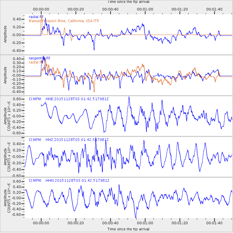
MPM Manuel Prospect Mine, California, USA - Earthquake Result Viewer
*The percent match for this event was below the threshold and hence no stack was calculated.
| Earthquake location: |
Kuril Islands |
| Earthquake latitude/longitude: |
43.3/146.5 |
| Earthquake time(UTC): |
2015/11/28 (332) 02:51:06 GMT |
| Earthquake Depth: |
60 km |
| Earthquake Magnitude: |
5.9 MB |
| Earthquake Catalog/Contributor: |
NEIC PDE/NEIC COMCAT |
|
| Network: |
CI Caltech Regional Seismic Network |
| Station: |
MPM Manuel Prospect Mine, California, USA |
| Lat/Lon: |
36.06 N/117.49 W |
| Elevation: |
185 m |
|
| Distance: |
70.2 deg |
| Az: |
58.919 deg |
| Baz: |
309.546 deg |
| Ray Param: |
$rayparam |
*The percent match for this event was below the threshold and hence was not used in the summary stack. |
|
| Radial Match: |
44.368523 % |
| Radial Bump: |
400 |
| Transverse Match: |
63.999607 % |
| Transverse Bump: |
400 |
| SOD ConfigId: |
7422571 |
| Insert Time: |
2019-04-21 12:35:04.234 +0000 |
| GWidth: |
2.5 |
| Max Bumps: |
400 |
| Tol: |
0.001 |
|
Signal To Noise
| Channel | StoN | STA | LTA |
| CI:MPM: :HHZ:20151128T03:01:42.517981Z | 0.6061491 | 1.4723297E-7 | 2.4289892E-7 |
| CI:MPM: :HHN:20151128T03:01:42.517981Z | 0.7472374 | 1.6483838E-7 | 2.2059709E-7 |
| CI:MPM: :HHE:20151128T03:01:42.517981Z | 1.2012166 | 2.3913825E-7 | 1.9908005E-7 |
| Arrivals |
| Ps | |
| PpPs | |
| PsPs/PpSs | |


