You are here: Home > Network List > TA - USArray Transportable Network (new EarthScope stations) Stations List
> Station A21K Barrow, AK, USA > Earthquake Result Viewer
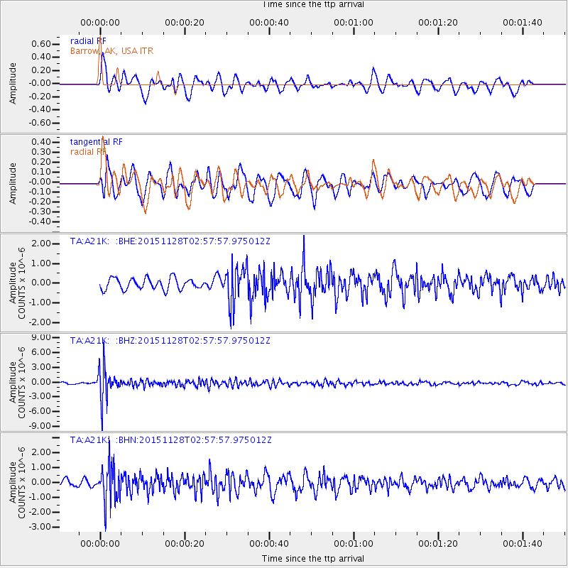
A21K Barrow, AK, USA - Earthquake Result Viewer
*The percent match for this event was below the threshold and hence no stack was calculated.
| Earthquake location: |
Kuril Islands |
| Earthquake latitude/longitude: |
43.3/146.5 |
| Earthquake time(UTC): |
2015/11/28 (332) 02:51:06 GMT |
| Earthquake Depth: |
60 km |
| Earthquake Magnitude: |
5.9 MB |
| Earthquake Catalog/Contributor: |
NEIC PDE/NEIC COMCAT |
|
| Network: |
TA USArray Transportable Network (new EarthScope stations) |
| Station: |
A21K Barrow, AK, USA |
| Lat/Lon: |
71.32 N/156.62 W |
| Elevation: |
577 m |
|
| Distance: |
39.1 deg |
| Az: |
25.325 deg |
| Baz: |
255.608 deg |
| Ray Param: |
$rayparam |
*The percent match for this event was below the threshold and hence was not used in the summary stack. |
|
| Radial Match: |
57.896534 % |
| Radial Bump: |
400 |
| Transverse Match: |
53.036823 % |
| Transverse Bump: |
400 |
| SOD ConfigId: |
7422571 |
| Insert Time: |
2019-04-21 12:39:42.742 +0000 |
| GWidth: |
2.5 |
| Max Bumps: |
400 |
| Tol: |
0.001 |
|
Signal To Noise
| Channel | StoN | STA | LTA |
| TA:A21K: :BHZ:20151128T02:57:57.975012Z | 26.998938 | 3.255124E-6 | 1.2056489E-7 |
| TA:A21K: :BHN:20151128T02:57:57.975012Z | 4.008374 | 1.2311914E-6 | 3.0715483E-7 |
| TA:A21K: :BHE:20151128T02:57:57.975012Z | 3.3648117 | 9.425403E-7 | 2.801168E-7 |
| Arrivals |
| Ps | |
| PpPs | |
| PsPs/PpSs | |


