You are here: Home > Network List > WY - Yellowstone Wyoming Seismic Network Stations List
> Station YHH Holmes Hill, YNP, WY, USA > Earthquake Result Viewer
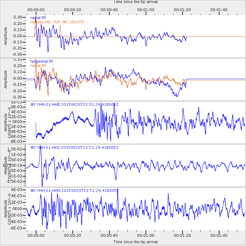
YHH Holmes Hill, YNP, WY, USA - Earthquake Result Viewer
*The percent match for this event was below the threshold and hence no stack was calculated.
| Earthquake location: |
South Of Fiji Islands |
| Earthquake latitude/longitude: |
-23.6/-177.1 |
| Earthquake time(UTC): |
2015/06/20 (171) 23:39:09 GMT |
| Earthquake Depth: |
158 km |
| Earthquake Magnitude: |
5.9 MO |
| Earthquake Catalog/Contributor: |
NEIC PDE/NEIC ALERT |
|
| Network: |
WY Yellowstone Wyoming Seismic Network |
| Station: |
YHH Holmes Hill, YNP, WY, USA |
| Lat/Lon: |
44.79 N/110.85 W |
| Elevation: |
2717 m |
|
| Distance: |
90.9 deg |
| Az: |
40.681 deg |
| Baz: |
237.14 deg |
| Ray Param: |
$rayparam |
*The percent match for this event was below the threshold and hence was not used in the summary stack. |
|
| Radial Match: |
60.86973 % |
| Radial Bump: |
400 |
| Transverse Match: |
41.93865 % |
| Transverse Bump: |
400 |
| SOD ConfigId: |
976571 |
| Insert Time: |
2015-07-05 00:12:42.588 +0000 |
| GWidth: |
2.5 |
| Max Bumps: |
400 |
| Tol: |
0.001 |
|
Signal To Noise
| Channel | StoN | STA | LTA |
| WY:YHH:01:HHZ:20150620T23:51:24.418005Z | 4.5913506 | 8.335583E-9 | 1.815497E-9 |
| WY:YHH:01:HHN:20150620T23:51:24.418005Z | 0.9254403 | 2.234302E-9 | 2.4143123E-9 |
| WY:YHH:01:HHE:20150620T23:51:24.418005Z | 0.83653283 | 2.5253877E-9 | 3.0188745E-9 |
| Arrivals |
| Ps | |
| PpPs | |
| PsPs/PpSs | |


