You are here: Home > Network List > TA - USArray Transportable Network (new EarthScope stations) Stations List
> Station MDND Maddock, ND, USA > Earthquake Result Viewer
MDND Maddock, ND, USA - Earthquake Result Viewer
*The percent match for this event was below the threshold and hence no stack was calculated.
| Earthquake location: |
Kuril Islands |
| Earthquake latitude/longitude: |
43.3/146.5 |
| Earthquake time(UTC): |
2015/11/28 (332) 02:51:06 GMT |
| Earthquake Depth: |
60 km |
| Earthquake Magnitude: |
5.9 MB |
| Earthquake Catalog/Contributor: |
NEIC PDE/NEIC COMCAT |
|
| Network: |
TA USArray Transportable Network (new EarthScope stations) |
| Station: |
MDND Maddock, ND, USA |
| Lat/Lon: |
47.85 N/99.60 W |
| Elevation: |
479 m |
|
| Distance: |
72.2 deg |
| Az: |
40.304 deg |
| Baz: |
315.524 deg |
| Ray Param: |
$rayparam |
*The percent match for this event was below the threshold and hence was not used in the summary stack. |
|
| Radial Match: |
55.799854 % |
| Radial Bump: |
359 |
| Transverse Match: |
57.640903 % |
| Transverse Bump: |
389 |
| SOD ConfigId: |
7422571 |
| Insert Time: |
2019-04-21 12:40:04.608 +0000 |
| GWidth: |
2.5 |
| Max Bumps: |
400 |
| Tol: |
0.001 |
|
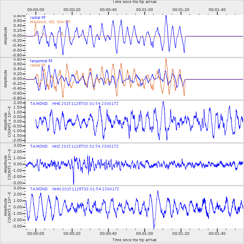
Signal To Noise
| Channel | StoN | STA | LTA |
| TA:MDND: :HHZ:20151128T03:01:54.230017Z | 2.3391962 | 4.6827572E-7 | 2.001866E-7 |
| TA:MDND: :HHN:20151128T03:01:54.230017Z | 3.0162714 | 1.4235147E-6 | 4.7194519E-7 |
| TA:MDND: :HHE:20151128T03:01:54.230017Z | 1.3114434 | 6.849789E-7 | 5.223091E-7 |
| Arrivals |
| Ps | |
| PpPs | |
| PsPs/PpSs | |


