You are here: Home > Network List > IC - New China Digital Seismograph Network Stations List
> Station KMI Kunming, Yunnan Province, China > Earthquake Result Viewer
KMI Kunming, Yunnan Province, China - Earthquake Result Viewer
| Earthquake location: |
Turkmenistan-Iran Border Region |
| Earthquake latitude/longitude: |
37.7/57.3 |
| Earthquake time(UTC): |
1997/02/04 (035) 10:37:47 GMT |
| Earthquake Depth: |
10 km |
| Earthquake Magnitude: |
5.9 MB, 6.8 MS, 6.5 UNKNOWN, 6.4 MW |
| Earthquake Catalog/Contributor: |
WHDF/NEIC |
|
| Network: |
IC New China Digital Seismograph Network |
| Station: |
KMI Kunming, Yunnan Province, China |
| Lat/Lon: |
25.12 N/102.74 E |
| Elevation: |
1975 m |
|
| Distance: |
40.4 deg |
| Az: |
94.587 deg |
| Baz: |
299.228 deg |
| Ray Param: |
0.074425526 |
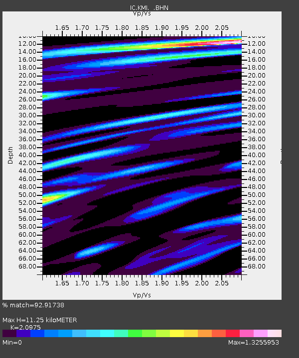
| Estimated Moho Depth: |
11.25 km |
| Estimated Crust Vp/Vs: |
2.10 |
| Assumed Crust Vp: |
6.247 km/s |
| Estimated Crust Vs: |
2.978 km/s |
| Estimated Crust Poisson's Ratio: |
0.35 |
|
| Radial Match: |
92.91738 % |
| Radial Bump: |
285 |
| Transverse Match: |
87.529755 % |
| Transverse Bump: |
400 |
| SOD ConfigId: |
6273 |
| Insert Time: |
2010-03-04 22:30:26.523 +0000 |
| GWidth: |
2.5 |
| Max Bumps: |
400 |
| Tol: |
0.001 |
|
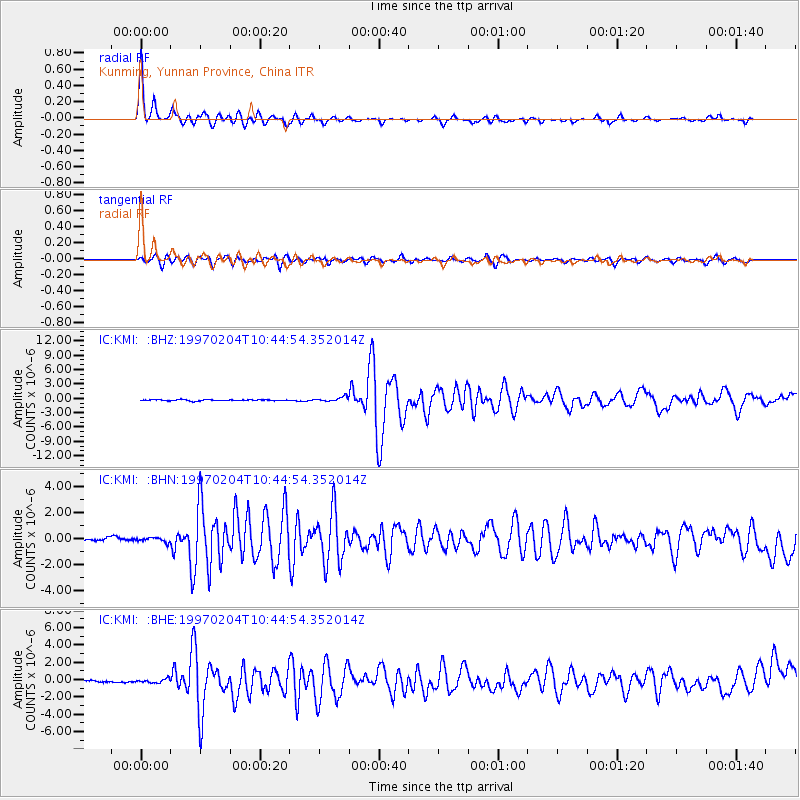
Signal To Noise
| Channel | StoN | STA | LTA |
| IC:KMI: :BHN:19970204T10:44:54.352014Z | 1.4204016 | 1.6781837E-7 | 1.18148535E-7 |
| IC:KMI: :BHE:19970204T10:44:54.352014Z | 3.049111 | 2.4261894E-7 | 7.9570384E-8 |
| IC:KMI: :BHZ:19970204T10:44:54.352014Z | 3.9806855 | 4.6498303E-7 | 1.16809794E-7 |
| Arrivals |
| Ps | 2.1 SECOND |
| PpPs | 5.3 SECOND |
| PsPs/PpSs | 7.4 SECOND |


