You are here: Home > Network List > IC - New China Digital Seismograph Network Stations List
> Station KMI Kunming, Yunnan Province, China > Earthquake Result Viewer
KMI Kunming, Yunnan Province, China - Earthquake Result Viewer
| Earthquake location: |
Northern And Central Iran |
| Earthquake latitude/longitude: |
33.8/59.8 |
| Earthquake time(UTC): |
1997/05/10 (130) 07:57:29 GMT |
| Earthquake Depth: |
10 km |
| Earthquake Magnitude: |
6.4 MB, 7.3 MS, 7.5 UNKNOWN, 7.2 MW |
| Earthquake Catalog/Contributor: |
WHDF/NEIC |
|
| Network: |
IC New China Digital Seismograph Network |
| Station: |
KMI Kunming, Yunnan Province, China |
| Lat/Lon: |
25.12 N/102.74 E |
| Elevation: |
1975 m |
|
| Distance: |
38.1 deg |
| Az: |
91.508 deg |
| Baz: |
293.361 deg |
| Ray Param: |
0.075731784 |
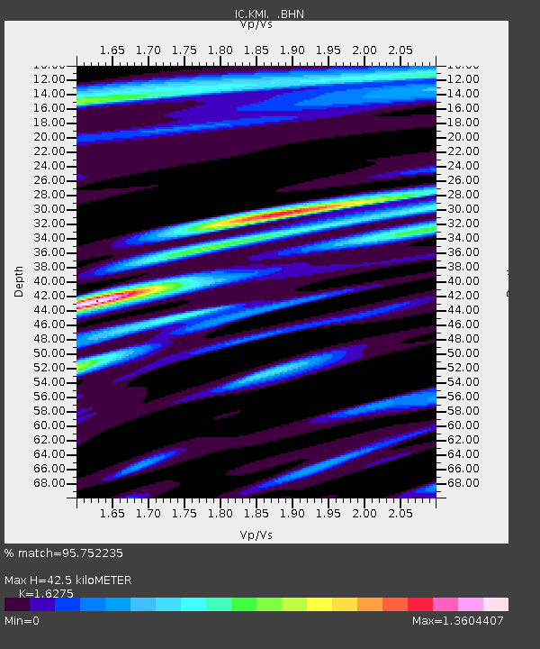
| Estimated Moho Depth: |
42.5 km |
| Estimated Crust Vp/Vs: |
1.63 |
| Assumed Crust Vp: |
6.247 km/s |
| Estimated Crust Vs: |
3.838 km/s |
| Estimated Crust Poisson's Ratio: |
0.20 |
|
| Radial Match: |
95.752235 % |
| Radial Bump: |
400 |
| Transverse Match: |
86.49515 % |
| Transverse Bump: |
400 |
| SOD ConfigId: |
6273 |
| Insert Time: |
2010-03-04 22:30:32.843 +0000 |
| GWidth: |
2.5 |
| Max Bumps: |
400 |
| Tol: |
0.001 |
|
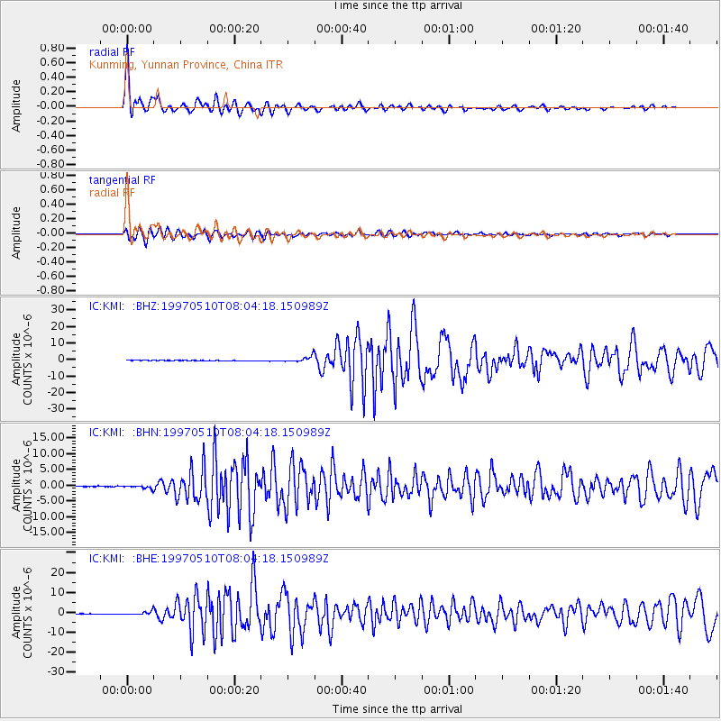
Signal To Noise
| Channel | StoN | STA | LTA |
| IC:KMI: :BHN:19970510T08:04:18.150989Z | 3.8499486 | 4.6278961E-7 | 1.2020669E-7 |
| IC:KMI: :BHE:19970510T08:04:18.150989Z | 6.7644396 | 8.083252E-7 | 1.1949626E-7 |
| IC:KMI: :BHZ:19970510T08:04:18.150989Z | 13.30648 | 1.8513731E-6 | 1.3913319E-7 |
| Arrivals |
| Ps | 4.6 SECOND |
| PpPs | 17 SECOND |
| PsPs/PpSs | 21 SECOND |


