You are here: Home > Network List > IC - New China Digital Seismograph Network Stations List
> Station KMI Kunming, Yunnan Province, China > Earthquake Result Viewer
KMI Kunming, Yunnan Province, China - Earthquake Result Viewer
| Earthquake location: |
Northern And Central Iran |
| Earthquake latitude/longitude: |
30.2/57.6 |
| Earthquake time(UTC): |
1998/03/14 (073) 19:40:27 GMT |
| Earthquake Depth: |
9.0 km |
| Earthquake Magnitude: |
5.9 MB, 6.9 MS, 6.6 UNKNOWN, 6.3 ME |
| Earthquake Catalog/Contributor: |
WHDF/NEIC |
|
| Network: |
IC New China Digital Seismograph Network |
| Station: |
KMI Kunming, Yunnan Province, China |
| Lat/Lon: |
25.12 N/102.74 E |
| Elevation: |
1975 m |
|
| Distance: |
40.1 deg |
| Az: |
85.896 deg |
| Baz: |
287.629 deg |
| Ray Param: |
0.07459 |
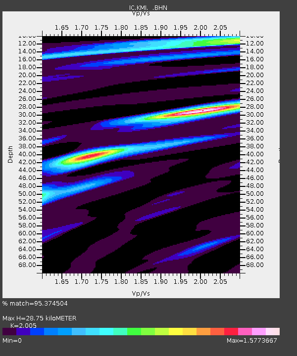
| Estimated Moho Depth: |
28.75 km |
| Estimated Crust Vp/Vs: |
2.01 |
| Assumed Crust Vp: |
6.247 km/s |
| Estimated Crust Vs: |
3.115 km/s |
| Estimated Crust Poisson's Ratio: |
0.33 |
|
| Radial Match: |
95.374504 % |
| Radial Bump: |
279 |
| Transverse Match: |
75.60357 % |
| Transverse Bump: |
400 |
| SOD ConfigId: |
6273 |
| Insert Time: |
2010-03-04 22:30:58.377 +0000 |
| GWidth: |
2.5 |
| Max Bumps: |
400 |
| Tol: |
0.001 |
|
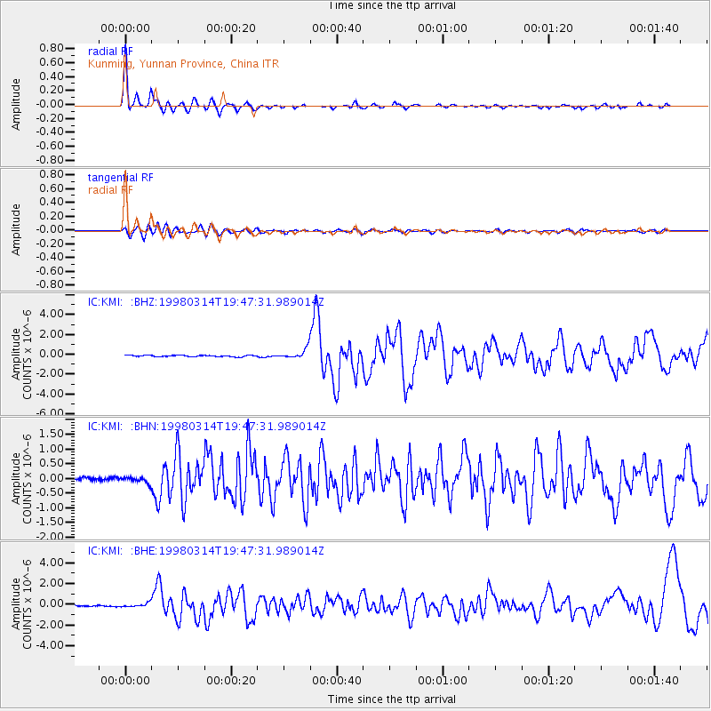
Signal To Noise
| Channel | StoN | STA | LTA |
| IC:KMI: :BHN:19980314T19:47:31.989014Z | 2.5090919 | 1.10948605E-7 | 4.421863E-8 |
| IC:KMI: :BHE:19980314T19:47:31.989014Z | 4.774452 | 2.0193534E-7 | 4.2294975E-8 |
| IC:KMI: :BHZ:19980314T19:47:31.989014Z | 7.4705997 | 5.117138E-7 | 6.8497016E-8 |
| Arrivals |
| Ps | 4.9 SECOND |
| PpPs | 13 SECOND |
| PsPs/PpSs | 18 SECOND |


