You are here: Home > Network List > IC - New China Digital Seismograph Network Stations List
> Station KMI Kunming, Yunnan Province, China > Earthquake Result Viewer
KMI Kunming, Yunnan Province, China - Earthquake Result Viewer
| Earthquake location: |
Balleny Islands Region |
| Earthquake latitude/longitude: |
-62.9/149.5 |
| Earthquake time(UTC): |
1998/03/25 (084) 03:12:25 GMT |
| Earthquake Depth: |
10 km |
| Earthquake Magnitude: |
6.6 MB, 8.0 MS, 8.3 UNKNOWN, 8.1 MW |
| Earthquake Catalog/Contributor: |
WHDF/NEIC |
|
| Network: |
IC New China Digital Seismograph Network |
| Station: |
KMI Kunming, Yunnan Province, China |
| Lat/Lon: |
25.12 N/102.74 E |
| Elevation: |
1975 m |
|
| Distance: |
95.2 deg |
| Az: |
318.44 deg |
| Baz: |
160.402 deg |
| Ray Param: |
0.040843062 |
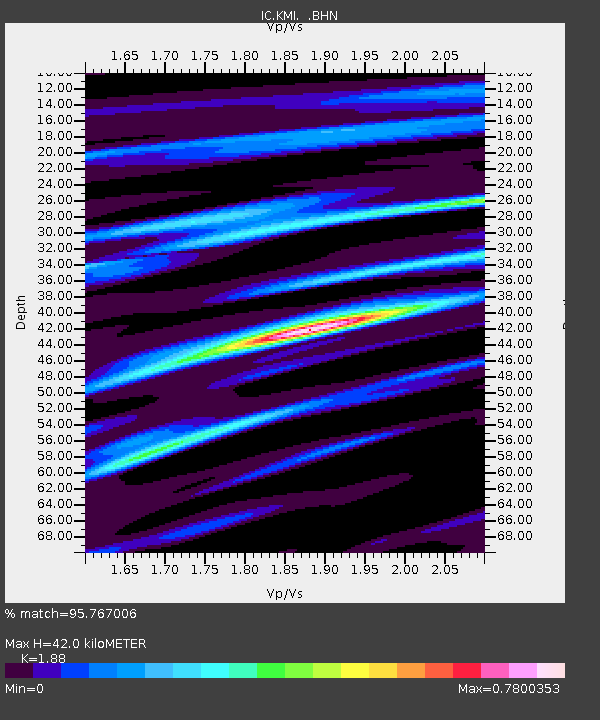
| Estimated Moho Depth: |
42.0 km |
| Estimated Crust Vp/Vs: |
1.88 |
| Assumed Crust Vp: |
6.247 km/s |
| Estimated Crust Vs: |
3.323 km/s |
| Estimated Crust Poisson's Ratio: |
0.30 |
|
| Radial Match: |
95.767006 % |
| Radial Bump: |
400 |
| Transverse Match: |
89.50155 % |
| Transverse Bump: |
400 |
| SOD ConfigId: |
6273 |
| Insert Time: |
2010-03-04 22:31:00.059 +0000 |
| GWidth: |
2.5 |
| Max Bumps: |
400 |
| Tol: |
0.001 |
|
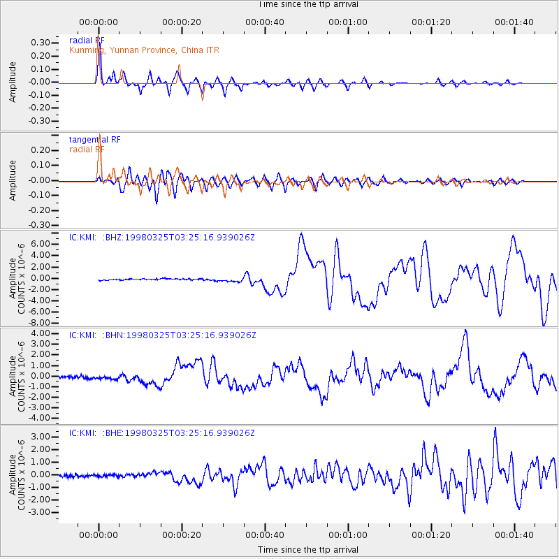
Signal To Noise
| Channel | StoN | STA | LTA |
| IC:KMI: :BHN:19980325T03:25:16.939026Z | 1.6799071 | 1.4546963E-7 | 8.659385E-8 |
| IC:KMI: :BHE:19980325T03:25:16.939026Z | 1.0152811 | 8.468324E-8 | 8.340867E-8 |
| IC:KMI: :BHZ:19980325T03:25:16.939026Z | 3.2684402 | 3.445173E-7 | 1.0540725E-7 |
| Arrivals |
| Ps | 6.0 SECOND |
| PpPs | 19 SECOND |
| PsPs/PpSs | 25 SECOND |


