You are here: Home > Network List > IC - New China Digital Seismograph Network Stations List
> Station KMI Kunming, Yunnan Province, China > Earthquake Result Viewer
KMI Kunming, Yunnan Province, China - Earthquake Result Viewer
| Earthquake location: |
Southeast Of Loyalty Islands |
| Earthquake latitude/longitude: |
-21.1/169.3 |
| Earthquake time(UTC): |
2007/09/27 (270) 19:57:44 GMT |
| Earthquake Depth: |
9.0 km |
| Earthquake Magnitude: |
6.2 MB, 6.3 MS, 6.1 MW, 6.1 MW |
| Earthquake Catalog/Contributor: |
WHDF/NEIC |
|
| Network: |
IC New China Digital Seismograph Network |
| Station: |
KMI Kunming, Yunnan Province, China |
| Lat/Lon: |
25.12 N/102.74 E |
| Elevation: |
1975 m |
|
| Distance: |
79.3 deg |
| Az: |
302.188 deg |
| Baz: |
119.337 deg |
| Ray Param: |
0.049062278 |
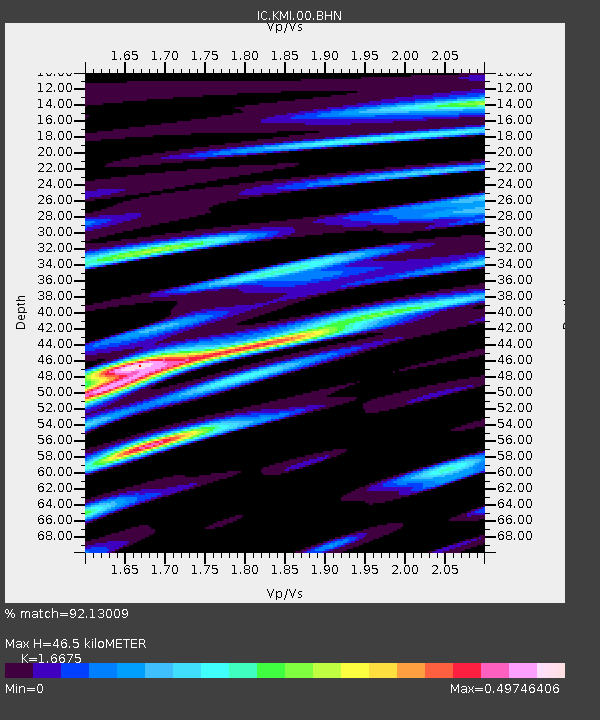
| Estimated Moho Depth: |
46.5 km |
| Estimated Crust Vp/Vs: |
1.67 |
| Assumed Crust Vp: |
6.247 km/s |
| Estimated Crust Vs: |
3.746 km/s |
| Estimated Crust Poisson's Ratio: |
0.22 |
|
| Radial Match: |
92.13009 % |
| Radial Bump: |
400 |
| Transverse Match: |
91.56168 % |
| Transverse Bump: |
400 |
| SOD ConfigId: |
2564 |
| Insert Time: |
2010-03-04 22:31:07.737 +0000 |
| GWidth: |
2.5 |
| Max Bumps: |
400 |
| Tol: |
0.001 |
|
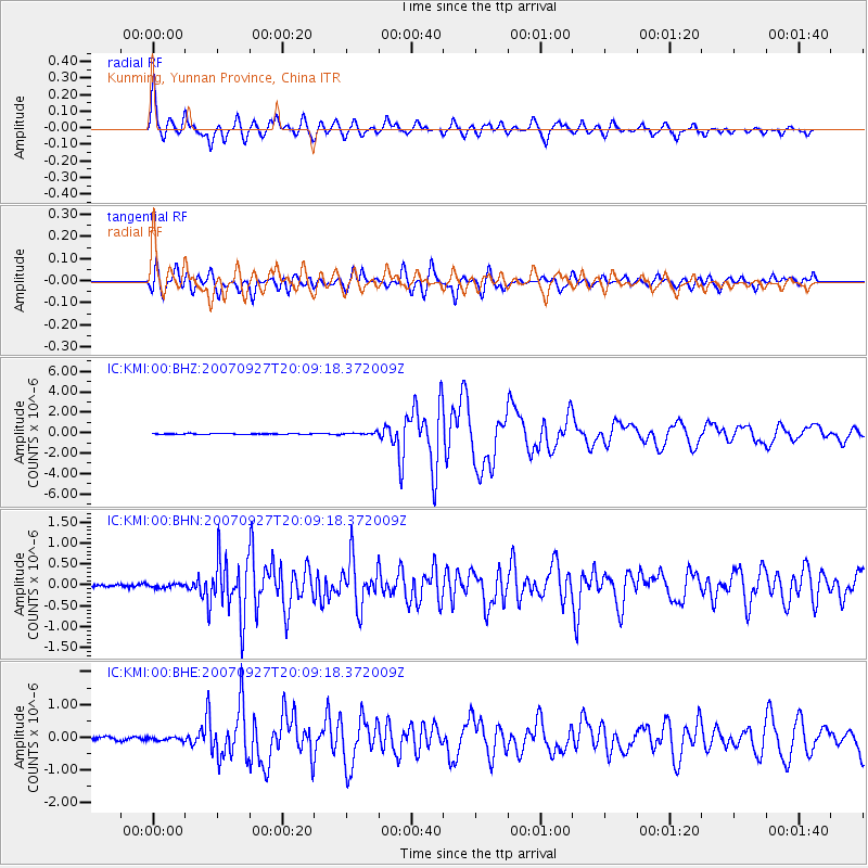
Signal To Noise
| Channel | StoN | STA | LTA |
| IC:KMI:00:BHN:20070927T20:09:18.372009Z | 1.4860466 | 4.5887056E-8 | 3.0878613E-8 |
| IC:KMI:00:BHE:20070927T20:09:18.372009Z | 1.4423358 | 5.1309947E-8 | 3.5574203E-8 |
| IC:KMI:00:BHZ:20070927T20:09:18.372009Z | 2.4798794 | 1.03296514E-7 | 4.1653845E-8 |
| Arrivals |
| Ps | 5.1 SECOND |
| PpPs | 19 SECOND |
| PsPs/PpSs | 24 SECOND |


