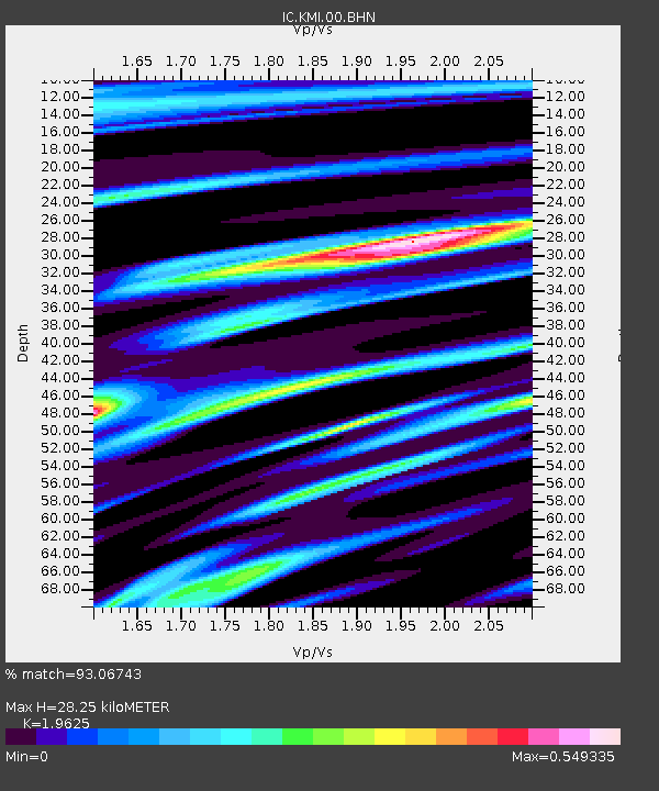
KMI Kunming, Yunnan Province, China - Earthquake Result Viewer
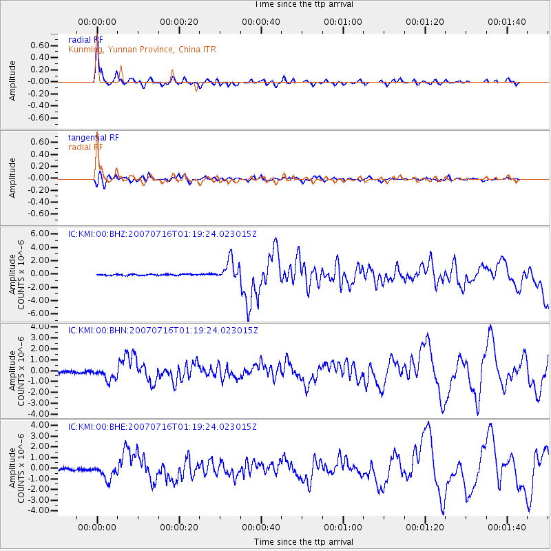
Earthquake location: Near West Coast Of Honshu, Japan
Earthquake latitude/longitude: 37.5/138.4
Earthquake time(UTC): 2007/07/16 (197) 01:13:22 GMT
Earthquake Depth: 12 km
Earthquake Magnitude: 6.5 MB, 6.4 MS, 6.6 MW, 6.5 MW
Earthquake Catalog/Contributor: WHDF/NEIC
Network: IC New China Digital Seismograph Network
Station: KMI Kunming, Yunnan Province, China
Lat/Lon: 25.12 N/102.74 E
Elevation: 1975 m
Distance: 32.7 deg
Az: 258.16 deg
Baz: 59.126 deg
Ray Param: 0.07852743
Estimated Moho Depth: 28.25 km
Estimated Crust Vp/Vs: 1.96
Assumed Crust Vp: 6.247 km/s
Estimated Crust Vs: 3.183 km/s
Estimated Crust Poisson's Ratio: 0.32
Radial Match: 93.06743 %
Radial Bump: 323
Transverse Match: 81.86209 %
Transverse Bump: 400
SOD ConfigId: 2564
Insert Time: 2010-03-04 22:31:10.690 +0000
GWidth: 2.5
Max Bumps: 400
Tol: 0.001

Signal To Noise

ChannelStoNSTALTA
IC:KMI:00:BHN:20070716T01:19:24.023015Z5.6529665.8192455E-71.02941456E-7
IC:KMI:00:BHE:20070716T01:19:24.023015Z6.2766247.279947E-71.1598507E-7
IC:KMI:00:BHZ:20070716T01:19:24.023015Z18.5222551.6115849E-68.700803E-8
Arrivals
Ps4.7 SECOND
PpPs13 SECOND
PsPs/PpSs17 SECOND