You are here: Home > Network List > CI - Caltech Regional Seismic Network Stations List
> Station MPM Manuel Prospect Mine, California, USA > Earthquake Result Viewer
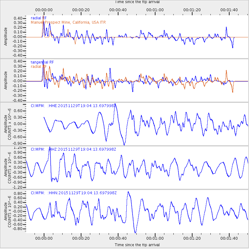
MPM Manuel Prospect Mine, California, USA - Earthquake Result Viewer
*The percent match for this event was below the threshold and hence no stack was calculated.
| Earthquake location: |
Jujuy Province, Argentina |
| Earthquake latitude/longitude: |
-23.5/-64.6 |
| Earthquake time(UTC): |
2015/11/29 (333) 18:52:49 GMT |
| Earthquake Depth: |
9.6 km |
| Earthquake Magnitude: |
5.9 MWP |
| Earthquake Catalog/Contributor: |
NEIC PDE/NEIC COMCAT |
|
| Network: |
CI Caltech Regional Seismic Network |
| Station: |
MPM Manuel Prospect Mine, California, USA |
| Lat/Lon: |
36.06 N/117.49 W |
| Elevation: |
185 m |
|
| Distance: |
77.5 deg |
| Az: |
318.565 deg |
| Baz: |
131.451 deg |
| Ray Param: |
$rayparam |
*The percent match for this event was below the threshold and hence was not used in the summary stack. |
|
| Radial Match: |
58.977436 % |
| Radial Bump: |
400 |
| Transverse Match: |
67.32632 % |
| Transverse Bump: |
400 |
| SOD ConfigId: |
7422571 |
| Insert Time: |
2019-04-21 12:50:57.322 +0000 |
| GWidth: |
2.5 |
| Max Bumps: |
400 |
| Tol: |
0.001 |
|
Signal To Noise
| Channel | StoN | STA | LTA |
| CI:MPM: :HHZ:20151129T19:04:13.697998Z | 1.4837505 | 5.97942E-7 | 4.0299363E-7 |
| CI:MPM: :HHN:20151129T19:04:13.697998Z | 1.0805186 | 2.7301127E-7 | 2.526669E-7 |
| CI:MPM: :HHE:20151129T19:04:13.697998Z | 3.1657064 | 4.5712568E-7 | 1.4439927E-7 |
| Arrivals |
| Ps | |
| PpPs | |
| PsPs/PpSs | |


