You are here: Home > Network List > IC - New China Digital Seismograph Network Stations List
> Station KMI Kunming, Yunnan Province, China > Earthquake Result Viewer
KMI Kunming, Yunnan Province, China - Earthquake Result Viewer
| Earthquake location: |
Java, Indonesia |
| Earthquake latitude/longitude: |
-7.8/107.3 |
| Earthquake time(UTC): |
2009/09/02 (245) 07:55:01 GMT |
| Earthquake Depth: |
46 km |
| Earthquake Magnitude: |
6.8 MB, 7.0 MS, 7.0 MW, 7.0 MW |
| Earthquake Catalog/Contributor: |
WHDF/NEIC |
|
| Network: |
IC New China Digital Seismograph Network |
| Station: |
KMI Kunming, Yunnan Province, China |
| Lat/Lon: |
25.12 N/102.74 E |
| Elevation: |
1975 m |
|
| Distance: |
33.0 deg |
| Az: |
352.402 deg |
| Baz: |
171.69 deg |
| Ray Param: |
0.078310534 |
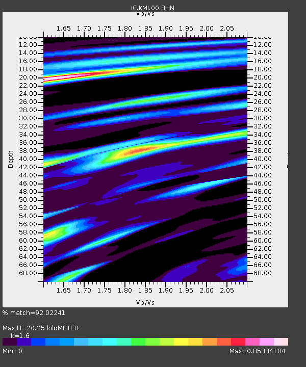
| Estimated Moho Depth: |
20.25 km |
| Estimated Crust Vp/Vs: |
1.60 |
| Assumed Crust Vp: |
6.247 km/s |
| Estimated Crust Vs: |
3.904 km/s |
| Estimated Crust Poisson's Ratio: |
0.18 |
|
| Radial Match: |
92.02241 % |
| Radial Bump: |
357 |
| Transverse Match: |
71.04442 % |
| Transverse Bump: |
400 |
| SOD ConfigId: |
2622 |
| Insert Time: |
2010-03-04 22:31:39.541 +0000 |
| GWidth: |
2.5 |
| Max Bumps: |
400 |
| Tol: |
0.001 |
|
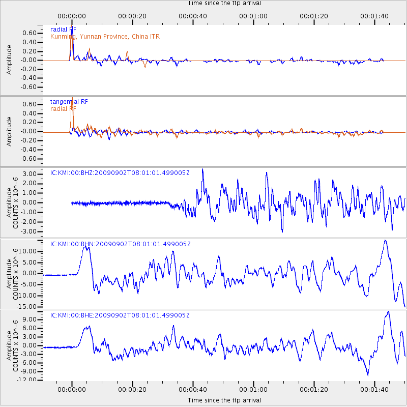
Signal To Noise
| Channel | StoN | STA | LTA |
| IC:KMI:00:BHN:20090902T08:01:01.499005Z | 30.203327 | 6.477305E-6 | 2.1445668E-7 |
| IC:KMI:00:BHE:20090902T08:01:01.499005Z | 17.131659 | 3.2449009E-6 | 1.8940963E-7 |
| IC:KMI:00:BHZ:20090902T08:01:01.499005Z | 2.6486518 | 2.2600398E-7 | 8.5327926E-8 |
| Arrivals |
| Ps | 2.1 SECOND |
| PpPs | 7.8 SECOND |
| PsPs/PpSs | 9.9 SECOND |


