You are here: Home > Network List > IC - New China Digital Seismograph Network Stations List
> Station KMI Kunming, Yunnan Province, China > Earthquake Result Viewer
KMI Kunming, Yunnan Province, China - Earthquake Result Viewer
| Earthquake location: |
Armenia-Azerbaijan-Iran Bord Reg |
| Earthquake latitude/longitude: |
38.7/48.5 |
| Earthquake time(UTC): |
1998/07/09 (190) 14:19:18 GMT |
| Earthquake Depth: |
26 km |
| Earthquake Magnitude: |
5.9 MB, 6.0 UNKNOWN, 5.7 ME |
| Earthquake Catalog/Contributor: |
WHDF/NEIC |
|
| Network: |
IC New China Digital Seismograph Network |
| Station: |
KMI Kunming, Yunnan Province, China |
| Lat/Lon: |
25.12 N/102.74 E |
| Elevation: |
1975 m |
|
| Distance: |
47.4 deg |
| Az: |
89.979 deg |
| Baz: |
300.346 deg |
| Ray Param: |
0.07000212 |
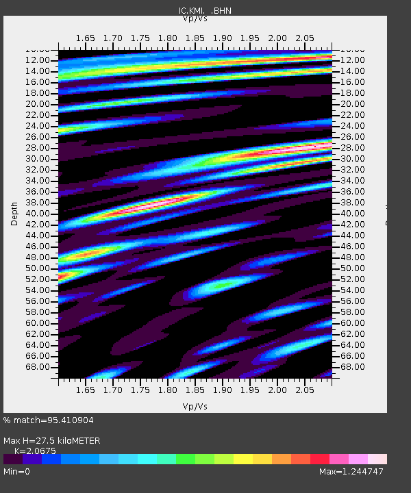
| Estimated Moho Depth: |
27.5 km |
| Estimated Crust Vp/Vs: |
2.07 |
| Assumed Crust Vp: |
6.247 km/s |
| Estimated Crust Vs: |
3.021 km/s |
| Estimated Crust Poisson's Ratio: |
0.35 |
|
| Radial Match: |
95.410904 % |
| Radial Bump: |
400 |
| Transverse Match: |
90.8365 % |
| Transverse Bump: |
400 |
| SOD ConfigId: |
4480 |
| Insert Time: |
2010-03-04 22:31:59.653 +0000 |
| GWidth: |
2.5 |
| Max Bumps: |
400 |
| Tol: |
0.001 |
|
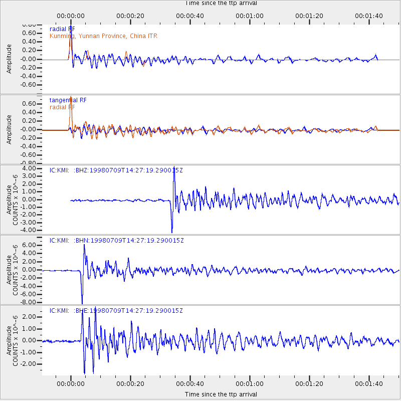
Signal To Noise
| Channel | StoN | STA | LTA |
| IC:KMI: :BHN:19980709T14:27:19.290015Z | 54.867798 | 2.7059284E-6 | 4.9317237E-8 |
| IC:KMI: :BHE:19980709T14:27:19.290015Z | 14.360216 | 9.825786E-7 | 6.842367E-8 |
| IC:KMI: :BHZ:19980709T14:27:19.290015Z | 24.292099 | 1.530671E-6 | 6.301107E-8 |
| Arrivals |
| Ps | 4.9 SECOND |
| PpPs | 13 SECOND |
| PsPs/PpSs | 18 SECOND |


