You are here: Home > Network List > IC - New China Digital Seismograph Network Stations List
> Station KMI Kunming, Yunnan Province, China > Earthquake Result Viewer
KMI Kunming, Yunnan Province, China - Earthquake Result Viewer
| Earthquake location: |
Hokkaido, Japan Region |
| Earthquake latitude/longitude: |
41.8/143.4 |
| Earthquake time(UTC): |
2009/06/05 (156) 03:30:33 GMT |
| Earthquake Depth: |
29 km |
| Earthquake Magnitude: |
6.0 MB, 6.3 MS, 6.4 MW, 6.4 MW |
| Earthquake Catalog/Contributor: |
WHDF/NEIC |
|
| Network: |
IC New China Digital Seismograph Network |
| Station: |
KMI Kunming, Yunnan Province, China |
| Lat/Lon: |
25.12 N/102.74 E |
| Elevation: |
1975 m |
|
| Distance: |
37.4 deg |
| Az: |
256.59 deg |
| Baz: |
53.325 deg |
| Ray Param: |
0.07609235 |
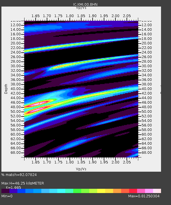
| Estimated Moho Depth: |
46.25 km |
| Estimated Crust Vp/Vs: |
1.66 |
| Assumed Crust Vp: |
6.247 km/s |
| Estimated Crust Vs: |
3.752 km/s |
| Estimated Crust Poisson's Ratio: |
0.22 |
|
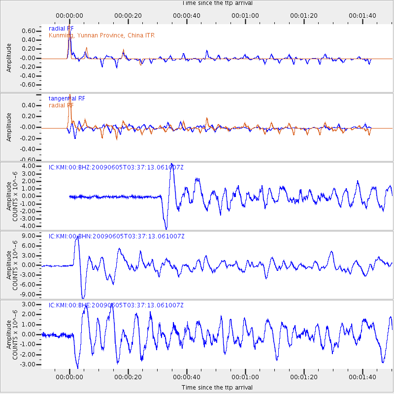
| Radial Match: |
92.07824 % |
| Radial Bump: |
400 |
| Transverse Match: |
90.85979 % |
| Transverse Bump: |
400 |
| SOD ConfigId: |
2648 |
| Insert Time: |
2010-03-04 22:32:01.945 +0000 |
| GWidth: |
2.5 |
| Max Bumps: |
400 |
| Tol: |
0.001 |
|
Signal To Noise
| Channel | StoN | STA | LTA |
| IC:KMI:00:BHN:20090605T03:37:13.061007Z | 53.079987 | 5.6710683E-6 | 1.0684005E-7 |
| IC:KMI:00:BHE:20090605T03:37:13.061007Z | 14.504195 | 1.6483685E-6 | 1.1364771E-7 |
| IC:KMI:00:BHZ:20090605T03:37:13.061007Z | 27.659151 | 2.261865E-6 | 8.177636E-8 |
| Arrivals |
| Ps | 5.3 SECOND |
| PpPs | 18 SECOND |
| PsPs/PpSs | 24 SECOND |


