You are here: Home > Network List > TA - USArray Transportable Network (new EarthScope stations) Stations List
> Station 121A Cookes Peak, Deming, NM, USA > Earthquake Result Viewer
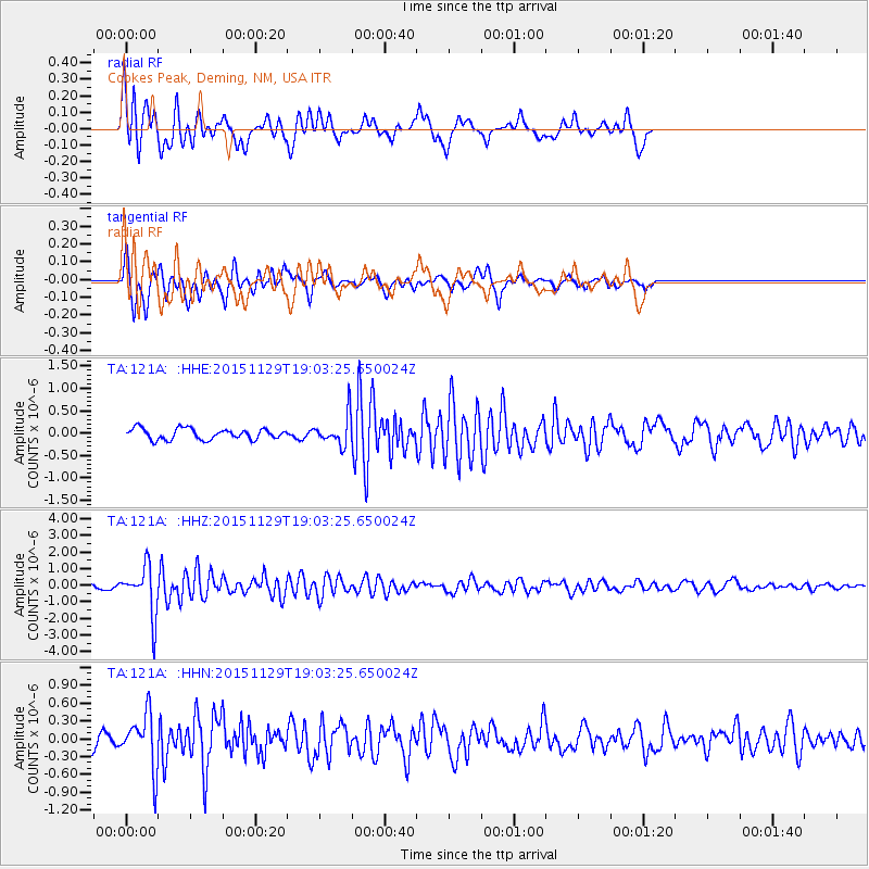
121A Cookes Peak, Deming, NM, USA - Earthquake Result Viewer
*The percent match for this event was below the threshold and hence no stack was calculated.
| Earthquake location: |
Jujuy Province, Argentina |
| Earthquake latitude/longitude: |
-23.5/-64.6 |
| Earthquake time(UTC): |
2015/11/29 (333) 18:52:49 GMT |
| Earthquake Depth: |
9.6 km |
| Earthquake Magnitude: |
5.9 MWP |
| Earthquake Catalog/Contributor: |
NEIC PDE/NEIC COMCAT |
|
| Network: |
TA USArray Transportable Network (new EarthScope stations) |
| Station: |
121A Cookes Peak, Deming, NM, USA |
| Lat/Lon: |
32.53 N/107.79 W |
| Elevation: |
1652 m |
|
| Distance: |
69.3 deg |
| Az: |
321.848 deg |
| Baz: |
137.844 deg |
| Ray Param: |
$rayparam |
*The percent match for this event was below the threshold and hence was not used in the summary stack. |
|
| Radial Match: |
79.852295 % |
| Radial Bump: |
400 |
| Transverse Match: |
74.58886 % |
| Transverse Bump: |
397 |
| SOD ConfigId: |
7422571 |
| Insert Time: |
2019-04-21 12:57:13.539 +0000 |
| GWidth: |
2.5 |
| Max Bumps: |
400 |
| Tol: |
0.001 |
|
Signal To Noise
| Channel | StoN | STA | LTA |
| TA:121A: :HHZ:20151129T19:03:25.650024Z | 8.202717 | 1.4568325E-6 | 1.7760365E-7 |
| TA:121A: :HHN:20151129T19:03:25.650024Z | 2.8742132 | 4.5993505E-7 | 1.600212E-7 |
| TA:121A: :HHE:20151129T19:03:25.650024Z | 2.7921472 | 3.3875824E-7 | 1.2132534E-7 |
| Arrivals |
| Ps | |
| PpPs | |
| PsPs/PpSs | |


