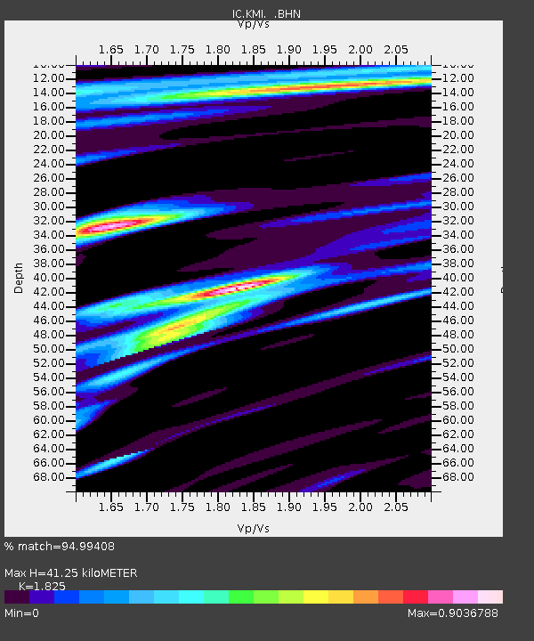
KMI Kunming, Yunnan Province, China - Earthquake Result Viewer

Earthquake location: Rat Islands, Aleutian Islands
Earthquake latitude/longitude: 51.3/179.5
Earthquake time(UTC): 1997/03/26 (085) 02:08:57 GMT
Earthquake Depth: 33 km
Earthquake Magnitude: 6.0 MB, 6.5 MS, 6.7 UNKNOWN, 6.3 ML
Earthquake Catalog/Contributor: WHDF/NEIC
Network: IC New China Digital Seismograph Network
Station: KMI Kunming, Yunnan Province, China
Lat/Lon: 25.12 N/102.74 E
Elevation: 1975 m
Distance: 62.7 deg
Az: 276.725 deg
Baz: 43.483 deg
Ray Param: 0.06000017
Estimated Moho Depth: 41.25 km
Estimated Crust Vp/Vs: 1.83
Assumed Crust Vp: 6.247 km/s
Estimated Crust Vs: 3.423 km/s
Estimated Crust Poisson's Ratio: 0.29
Radial Match: 94.99408 %
Radial Bump: 400
Transverse Match: 86.77264 %
Transverse Bump: 400
SOD ConfigId: 4480
Insert Time: 2010-03-04 22:33:21.942 +0000
GWidth: 2.5
Max Bumps: 400
Tol: 0.001

Signal To Noise

ChannelStoNSTALTA
IC:KMI: :BHN:19970326T02:18:48.002002Z30.2846222.0185196E-66.665163E-8
IC:KMI: :BHE:19970326T02:18:48.002002Z8.9287125.8764647E-76.581537E-8
IC:KMI: :BHZ:19970326T02:18:48.002002Z7.49024344.9711207E-76.6367946E-8
Arrivals
Ps5.7 SECOND
PpPs18 SECOND
PsPs/PpSs24 SECOND