You are here: Home > Network List > TA - USArray Transportable Network (new EarthScope stations) Stations List
> Station N23A Red Feather Lakes, CO, USA > Earthquake Result Viewer
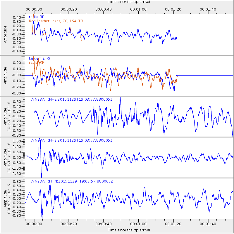
N23A Red Feather Lakes, CO, USA - Earthquake Result Viewer
*The percent match for this event was below the threshold and hence no stack was calculated.
| Earthquake location: |
Jujuy Province, Argentina |
| Earthquake latitude/longitude: |
-23.5/-64.6 |
| Earthquake time(UTC): |
2015/11/29 (333) 18:52:49 GMT |
| Earthquake Depth: |
9.6 km |
| Earthquake Magnitude: |
5.9 MWP |
| Earthquake Catalog/Contributor: |
NEIC PDE/NEIC COMCAT |
|
| Network: |
TA USArray Transportable Network (new EarthScope stations) |
| Station: |
N23A Red Feather Lakes, CO, USA |
| Lat/Lon: |
40.89 N/105.94 W |
| Elevation: |
2458 m |
|
| Distance: |
74.7 deg |
| Az: |
328.732 deg |
| Baz: |
141.07 deg |
| Ray Param: |
$rayparam |
*The percent match for this event was below the threshold and hence was not used in the summary stack. |
|
| Radial Match: |
58.92556 % |
| Radial Bump: |
400 |
| Transverse Match: |
68.000694 % |
| Transverse Bump: |
400 |
| SOD ConfigId: |
7422571 |
| Insert Time: |
2019-04-21 12:57:39.022 +0000 |
| GWidth: |
2.5 |
| Max Bumps: |
400 |
| Tol: |
0.001 |
|
Signal To Noise
| Channel | StoN | STA | LTA |
| TA:N23A: :HHZ:20151129T19:03:57.880005Z | 7.7082853 | 8.4687633E-7 | 1.09865724E-7 |
| TA:N23A: :HHN:20151129T19:03:57.880005Z | 1.7033106 | 3.254763E-7 | 1.9108452E-7 |
| TA:N23A: :HHE:20151129T19:03:57.880005Z | 0.9171408 | 1.7264557E-7 | 1.8824326E-7 |
| Arrivals |
| Ps | |
| PpPs | |
| PsPs/PpSs | |


