You are here: Home > Network List > TA - USArray Transportable Network (new EarthScope stations) Stations List
> Station R11A Troy Canyon, Currant, NV, USA > Earthquake Result Viewer
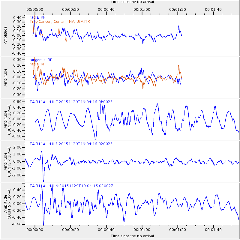
R11A Troy Canyon, Currant, NV, USA - Earthquake Result Viewer
*The percent match for this event was below the threshold and hence no stack was calculated.
| Earthquake location: |
Jujuy Province, Argentina |
| Earthquake latitude/longitude: |
-23.5/-64.6 |
| Earthquake time(UTC): |
2015/11/29 (333) 18:52:49 GMT |
| Earthquake Depth: |
9.6 km |
| Earthquake Magnitude: |
5.9 MWP |
| Earthquake Catalog/Contributor: |
NEIC PDE/NEIC COMCAT |
|
| Network: |
TA USArray Transportable Network (new EarthScope stations) |
| Station: |
R11A Troy Canyon, Currant, NV, USA |
| Lat/Lon: |
38.35 N/115.59 W |
| Elevation: |
1756 m |
|
| Distance: |
77.9 deg |
| Az: |
321.343 deg |
| Baz: |
133.188 deg |
| Ray Param: |
$rayparam |
*The percent match for this event was below the threshold and hence was not used in the summary stack. |
|
| Radial Match: |
74.854546 % |
| Radial Bump: |
352 |
| Transverse Match: |
80.03215 % |
| Transverse Bump: |
344 |
| SOD ConfigId: |
7422571 |
| Insert Time: |
2019-04-21 12:57:48.843 +0000 |
| GWidth: |
2.5 |
| Max Bumps: |
400 |
| Tol: |
0.001 |
|
Signal To Noise
| Channel | StoN | STA | LTA |
| TA:R11A: :HHZ:20151129T19:04:16.02002Z | 4.334062 | 9.4803073E-7 | 2.1873953E-7 |
| TA:R11A: :HHN:20151129T19:04:16.02002Z | 2.3431253 | 2.4903883E-7 | 1.06284894E-7 |
| TA:R11A: :HHE:20151129T19:04:16.02002Z | 1.7887653 | 3.8492718E-7 | 2.1519153E-7 |
| Arrivals |
| Ps | |
| PpPs | |
| PsPs/PpSs | |


