You are here: Home > Network List > US - United States National Seismic Network Stations List
> Station DGMT Dagmar, Montana, USA > Earthquake Result Viewer
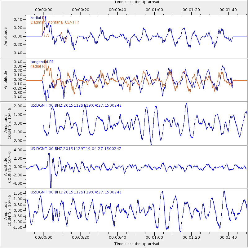
DGMT Dagmar, Montana, USA - Earthquake Result Viewer
*The percent match for this event was below the threshold and hence no stack was calculated.
| Earthquake location: |
Jujuy Province, Argentina |
| Earthquake latitude/longitude: |
-23.5/-64.6 |
| Earthquake time(UTC): |
2015/11/29 (333) 18:52:49 GMT |
| Earthquake Depth: |
9.6 km |
| Earthquake Magnitude: |
5.9 MWP |
| Earthquake Catalog/Contributor: |
NEIC PDE/NEIC COMCAT |
|
| Network: |
US United States National Seismic Network |
| Station: |
DGMT Dagmar, Montana, USA |
| Lat/Lon: |
48.47 N/104.20 W |
| Elevation: |
0.0 m |
|
| Distance: |
80.0 deg |
| Az: |
334.488 deg |
| Baz: |
143.562 deg |
| Ray Param: |
$rayparam |
*The percent match for this event was below the threshold and hence was not used in the summary stack. |
|
| Radial Match: |
57.517086 % |
| Radial Bump: |
364 |
| Transverse Match: |
55.677853 % |
| Transverse Bump: |
400 |
| SOD ConfigId: |
7422571 |
| Insert Time: |
2019-04-21 12:58:18.641 +0000 |
| GWidth: |
2.5 |
| Max Bumps: |
400 |
| Tol: |
0.001 |
|
Signal To Noise
| Channel | StoN | STA | LTA |
| US:DGMT:00:BHZ:20151129T19:04:27.150024Z | 7.762668 | 2.1239293E-6 | 2.7360815E-7 |
| US:DGMT:00:BH1:20151129T19:04:27.150024Z | 0.6853025 | 4.6223576E-7 | 6.744989E-7 |
| US:DGMT:00:BH2:20151129T19:04:27.150024Z | 0.5830726 | 5.8050074E-7 | 9.955892E-7 |
| Arrivals |
| Ps | |
| PpPs | |
| PsPs/PpSs | |


