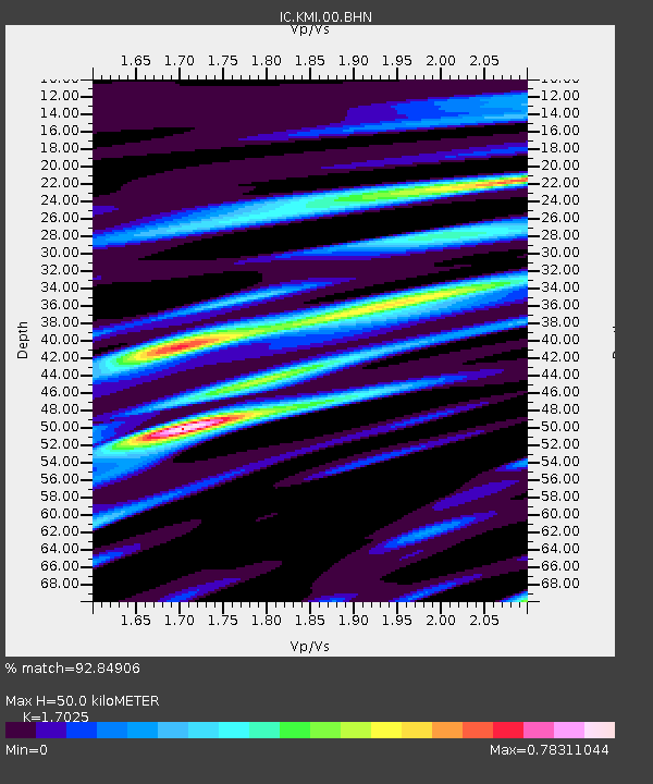
KMI Kunming, Yunnan Province, China - Earthquake Result Viewer
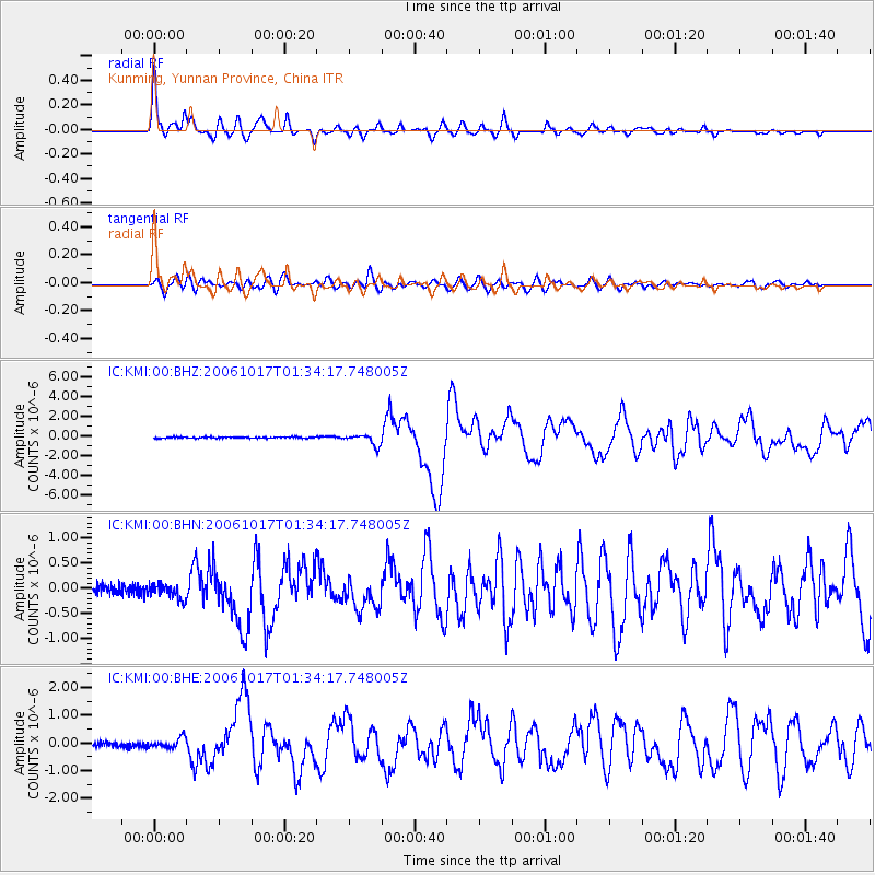
Earthquake location: New Britain Region, P.N.G.
Earthquake latitude/longitude: -5.9/151.0
Earthquake time(UTC): 2006/10/17 (290) 01:25:12 GMT
Earthquake Depth: 32 km
Earthquake Magnitude: 6.4 MB, 6.9 MS, 6.7 MW, 6.6 MW
Earthquake Catalog/Contributor: WHDF/NEIC
Network: IC New China Digital Seismograph Network
Station: KMI Kunming, Yunnan Province, China
Lat/Lon: 25.12 N/102.74 E
Elevation: 1975 m
Distance: 56.1 deg
Az: 305.452 deg
Baz: 116.624 deg
Ray Param: 0.0642991
Estimated Moho Depth: 50.0 km
Estimated Crust Vp/Vs: 1.70
Assumed Crust Vp: 6.247 km/s
Estimated Crust Vs: 3.669 km/s
Estimated Crust Poisson's Ratio: 0.24
Radial Match: 92.84906 %
Radial Bump: 400
Transverse Match: 76.08056 %
Transverse Bump: 400
SOD ConfigId: 2564
Insert Time: 2010-03-04 22:33:49.045 +0000
GWidth: 2.5
Max Bumps: 400
Tol: 0.001

Signal To Noise

ChannelStoNSTALTA
IC:KMI:00:BHN:20061017T01:34:17.748005Z1.33692461.4192541E-71.0615814E-7
IC:KMI:00:BHE:20061017T01:34:17.748005Z1.99582961.8053404E-79.045564E-8
IC:KMI:00:BHZ:20061017T01:34:17.748005Z9.1990115.730561E-76.2295406E-8
Arrivals
Ps5.9 SECOND
PpPs21 SECOND
PsPs/PpSs26 SECOND