You are here: Home > Network List > IC - New China Digital Seismograph Network Stations List
> Station KMI Kunming, Yunnan Province, China > Earthquake Result Viewer
KMI Kunming, Yunnan Province, China - Earthquake Result Viewer
| Earthquake location: |
South Of Java, Indonesia |
| Earthquake latitude/longitude: |
-9.9/107.3 |
| Earthquake time(UTC): |
2006/09/19 (262) 13:58:56 GMT |
| Earthquake Depth: |
12 km |
| Earthquake Magnitude: |
5.9 MB, 5.5 MS, 5.9 MW, 5.9 MW |
| Earthquake Catalog/Contributor: |
WHDF/NEIC |
|
| Network: |
IC New China Digital Seismograph Network |
| Station: |
KMI Kunming, Yunnan Province, China |
| Lat/Lon: |
25.12 N/102.74 E |
| Elevation: |
1975 m |
|
| Distance: |
35.1 deg |
| Az: |
352.727 deg |
| Baz: |
172.091 deg |
| Ray Param: |
0.07739412 |
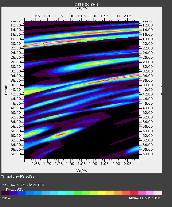
| Estimated Moho Depth: |
19.75 km |
| Estimated Crust Vp/Vs: |
1.68 |
| Assumed Crust Vp: |
6.247 km/s |
| Estimated Crust Vs: |
3.713 km/s |
| Estimated Crust Poisson's Ratio: |
0.23 |
|
| Radial Match: |
93.9339 % |
| Radial Bump: |
400 |
| Transverse Match: |
91.281685 % |
| Transverse Bump: |
400 |
| SOD ConfigId: |
2564 |
| Insert Time: |
2010-03-04 22:33:57.354 +0000 |
| GWidth: |
2.5 |
| Max Bumps: |
400 |
| Tol: |
0.001 |
|
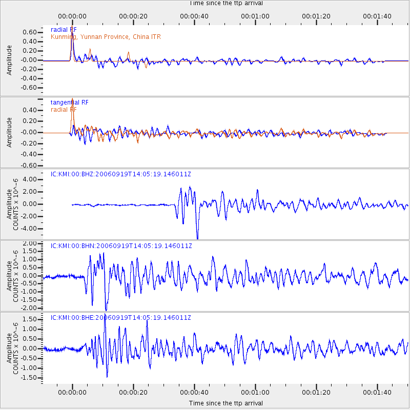
Signal To Noise
| Channel | StoN | STA | LTA |
| IC:KMI:00:BHN:20060919T14:05:19.146011Z | 5.426795 | 2.9247366E-7 | 5.3894365E-8 |
| IC:KMI:00:BHE:20060919T14:05:19.146011Z | 1.9835783 | 1.0598299E-7 | 5.3430202E-8 |
| IC:KMI:00:BHZ:20060919T14:05:19.146011Z | 8.613353 | 6.1087724E-7 | 7.092212E-8 |
| Arrivals |
| Ps | 2.3 SECOND |
| PpPs | 7.9 SECOND |
| PsPs/PpSs | 10 SECOND |


