You are here: Home > Network List > CI - Caltech Regional Seismic Network Stations List
> Station VES Vestal, Richgrove, CA, USA > Earthquake Result Viewer
VES Vestal, Richgrove, CA, USA - Earthquake Result Viewer
| Earthquake location: |
Tonga Islands Region |
| Earthquake latitude/longitude: |
-17.3/-171.9 |
| Earthquake time(UTC): |
2008/12/24 (359) 09:11:34 GMT |
| Earthquake Depth: |
9.0 km |
| Earthquake Magnitude: |
5.9 MB, 5.6 MS, 6.0 MW, 6.0 MW |
| Earthquake Catalog/Contributor: |
WHDF/NEIC |
|
| Network: |
CI Caltech Regional Seismic Network |
| Station: |
VES Vestal, Richgrove, CA, USA |
| Lat/Lon: |
35.84 N/119.08 W |
| Elevation: |
154 m |
|
| Distance: |
72.7 deg |
| Az: |
42.684 deg |
| Baz: |
232.86 deg |
| Ray Param: |
0.053469893 |
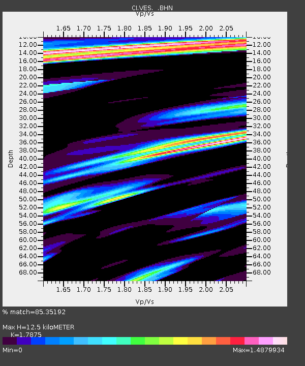
| Estimated Moho Depth: |
12.5 km |
| Estimated Crust Vp/Vs: |
1.79 |
| Assumed Crust Vp: |
6.1 km/s |
| Estimated Crust Vs: |
3.413 km/s |
| Estimated Crust Poisson's Ratio: |
0.27 |
|
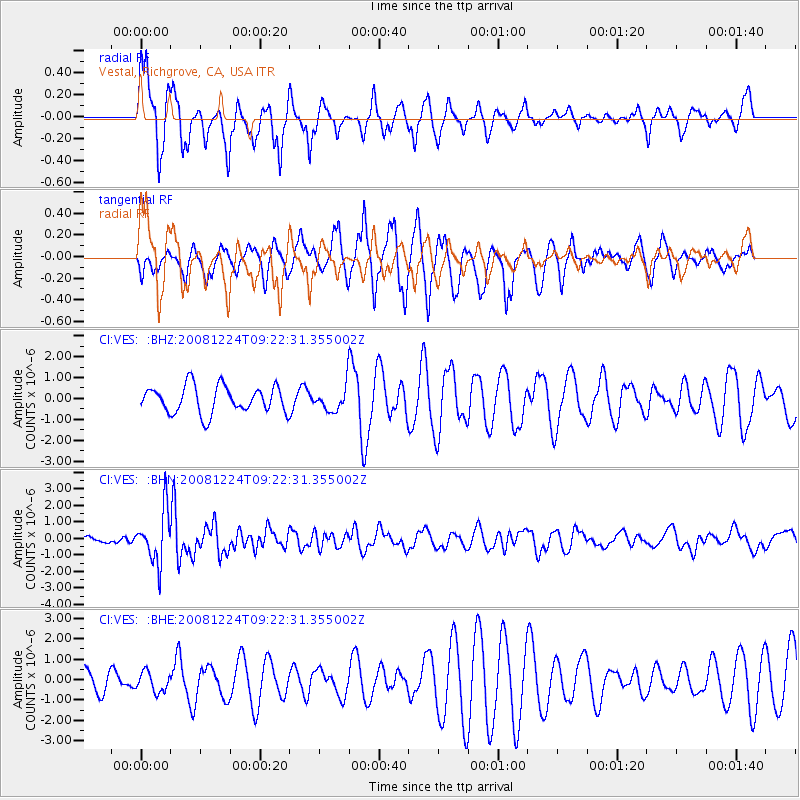
| Radial Match: |
85.35192 % |
| Radial Bump: |
369 |
| Transverse Match: |
73.956985 % |
| Transverse Bump: |
378 |
| SOD ConfigId: |
2658 |
| Insert Time: |
2010-02-26 00:00:04.241 +0000 |
| GWidth: |
2.5 |
| Max Bumps: |
400 |
| Tol: |
0.001 |
|
Signal To Noise
| Channel | StoN | STA | LTA |
| CI:VES: :BHN:20081224T09:22:31.355002Z | 10.357757 | 1.5829477E-6 | 1.5282727E-7 |
| CI:VES: :BHE:20081224T09:22:31.355002Z | 0.880073 | 4.881879E-7 | 5.547129E-7 |
| CI:VES: :BHZ:20081224T09:22:31.355002Z | 0.93514943 | 6.048658E-7 | 6.46812E-7 |
| Arrivals |
| Ps | 1.7 SECOND |
| PpPs | 5.5 SECOND |
| PsPs/PpSs | 7.2 SECOND |


