You are here: Home > Network List > IC - New China Digital Seismograph Network Stations List
> Station KMI Kunming, Yunnan Province, China > Earthquake Result Viewer
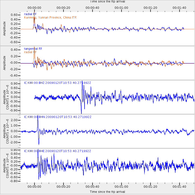
KMI Kunming, Yunnan Province, China - Earthquake Result Viewer
*The percent match for this event was below the threshold and hence no stack was calculated.
| Earthquake location: |
Banda Sea |
| Earthquake latitude/longitude: |
-4.7/129.8 |
| Earthquake time(UTC): |
2009/01/20 (020) 10:46:53 GMT |
| Earthquake Depth: |
144 km |
| Earthquake Magnitude: |
5.7 MB, 5.5 MW, 5.5 MW |
| Earthquake Catalog/Contributor: |
WHDF/NEIC |
|
| Network: |
IC New China Digital Seismograph Network |
| Station: |
KMI Kunming, Yunnan Province, China |
| Lat/Lon: |
25.12 N/102.74 E |
| Elevation: |
1975 m |
|
| Distance: |
39.6 deg |
| Az: |
319.676 deg |
| Baz: |
134.641 deg |
| Ray Param: |
$rayparam |
*The percent match for this event was below the threshold and hence was not used in the summary stack. |
|
| Radial Match: |
68.0599 % |
| Radial Bump: |
400 |
| Transverse Match: |
63.06396 % |
| Transverse Bump: |
400 |
| SOD ConfigId: |
2658 |
| Insert Time: |
2010-03-04 22:35:20.970 +0000 |
| GWidth: |
2.5 |
| Max Bumps: |
400 |
| Tol: |
0.001 |
|
Signal To Noise
| Channel | StoN | STA | LTA |
| IC:KMI:00:BHN:20090120T10:53:40.271992Z | 12.396899 | 9.552432E-7 | 7.705501E-8 |
| IC:KMI:00:BHE:20090120T10:53:40.271992Z | 3.7747517 | 3.2317584E-7 | 8.561513E-8 |
| IC:KMI:00:BHZ:20090120T10:53:40.271992Z | 5.0364027 | 4.3362311E-7 | 8.609778E-8 |
| Arrivals |
| Ps | |
| PpPs | |
| PsPs/PpSs | |


