You are here: Home > Network List > YT07 - POLENET Stations List
> Station WAWA WAWA > Earthquake Result Viewer
WAWA WAWA - Earthquake Result Viewer
| Earthquake location: |
Fiji Islands Region |
| Earthquake latitude/longitude: |
-14.9/-176.6 |
| Earthquake time(UTC): |
2015/12/01 (335) 17:08:25 GMT |
| Earthquake Depth: |
10 km |
| Earthquake Magnitude: |
5.6 MB |
| Earthquake Catalog/Contributor: |
NEIC PDE/NEIC COMCAT |
|
| Network: |
YT POLENET |
| Station: |
WAWA WAWA |
| Lat/Lon: |
81.58 S/28.42 W |
| Elevation: |
1202 m |
|
| Distance: |
82.4 deg |
| Az: |
175.502 deg |
| Baz: |
210.944 deg |
| Ray Param: |
0.04690444 |
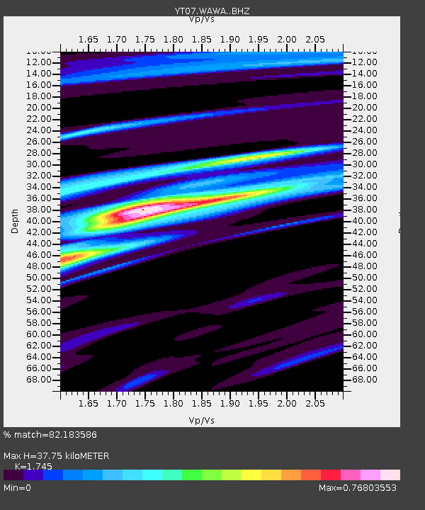
| Estimated Moho Depth: |
37.75 km |
| Estimated Crust Vp/Vs: |
1.75 |
| Assumed Crust Vp: |
6.424 km/s |
| Estimated Crust Vs: |
3.681 km/s |
| Estimated Crust Poisson's Ratio: |
0.26 |
|
| Radial Match: |
82.183586 % |
| Radial Bump: |
400 |
| Transverse Match: |
70.411415 % |
| Transverse Bump: |
400 |
| SOD ConfigId: |
7422571 |
| Insert Time: |
2019-04-21 13:18:03.313 +0000 |
| GWidth: |
2.5 |
| Max Bumps: |
400 |
| Tol: |
0.001 |
|

Signal To Noise
| Channel | StoN | STA | LTA |
| YT:WAWA: :BHZ:20151201T17:20:16.125012Z | 2.5008202 | 2.7700594E-7 | 1.1076603E-7 |
| YT:WAWA: :BHN:20151201T17:20:16.125012Z | 2.5634797 | 9.7729085E-8 | 3.8123606E-8 |
| YT:WAWA: :BHE:20151201T17:20:16.125012Z | 0.95184857 | 5.2421168E-8 | 5.5073013E-8 |
| Arrivals |
| Ps | 4.5 SECOND |
| PpPs | 16 SECOND |
| PsPs/PpSs | 20 SECOND |


