You are here: Home > Network List > IC - New China Digital Seismograph Network Stations List
> Station KMI Kunming, Yunnan Province, China > Earthquake Result Viewer
KMI Kunming, Yunnan Province, China - Earthquake Result Viewer
*The percent match for this event was below the threshold and hence no stack was calculated.
| Earthquake location: |
Banda Sea |
| Earthquake latitude/longitude: |
-7.5/127.7 |
| Earthquake time(UTC): |
2008/10/21 (295) 13:00:48 GMT |
| Earthquake Depth: |
135 km |
| Earthquake Magnitude: |
5.5 MB, 5.6 MW, 5.5 MW |
| Earthquake Catalog/Contributor: |
WHDF/NEIC |
|
| Network: |
IC New China Digital Seismograph Network |
| Station: |
KMI Kunming, Yunnan Province, China |
| Lat/Lon: |
25.12 N/102.74 E |
| Elevation: |
1975 m |
|
| Distance: |
40.5 deg |
| Az: |
323.88 deg |
| Baz: |
139.846 deg |
| Ray Param: |
$rayparam |
*The percent match for this event was below the threshold and hence was not used in the summary stack. |
|
| Radial Match: |
67.602806 % |
| Radial Bump: |
400 |
| Transverse Match: |
68.275215 % |
| Transverse Bump: |
400 |
| SOD ConfigId: |
2658 |
| Insert Time: |
2010-03-04 22:35:54.067 +0000 |
| GWidth: |
2.5 |
| Max Bumps: |
400 |
| Tol: |
0.001 |
|
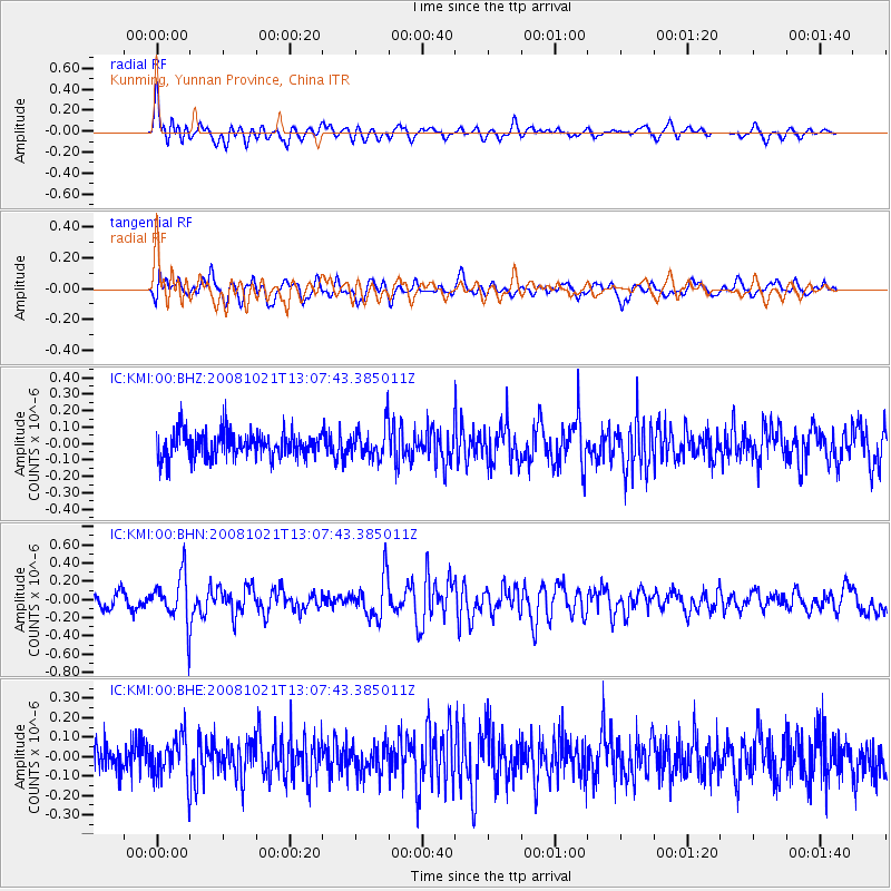
Signal To Noise
| Channel | StoN | STA | LTA |
| IC:KMI:00:BHN:20081021T13:07:43.385011Z | 3.666739 | 2.6051762E-7 | 7.104886E-8 |
| IC:KMI:00:BHE:20081021T13:07:43.385011Z | 1.2510749 | 1.06055985E-7 | 8.477189E-8 |
| IC:KMI:00:BHZ:20081021T13:07:43.385011Z | 1.2236727 | 9.5644054E-8 | 7.816147E-8 |
| Arrivals |
| Ps | |
| PpPs | |
| PsPs/PpSs | |


