You are here: Home > Network List > KN - Kyrgyz Seismic Telemetry Network Stations List
> Station TKM2 - > Earthquake Result Viewer
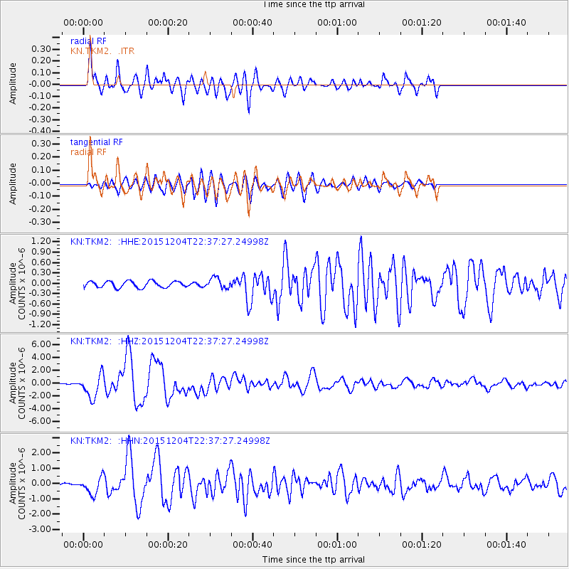
TKM2 - - Earthquake Result Viewer
*The percent match for this event was below the threshold and hence no stack was calculated.
| Earthquake location: |
Southeast Indian Ridge |
| Earthquake latitude/longitude: |
-47.7/85.2 |
| Earthquake time(UTC): |
2015/12/04 (338) 22:24:54 GMT |
| Earthquake Depth: |
10 km |
| Earthquake Magnitude: |
7.1 MWP |
| Earthquake Catalog/Contributor: |
NEIC PDE/NEIC COMCAT |
|
| Network: |
KN Kyrgyz Seismic Telemetry Network |
| Station: |
TKM2 - |
| Lat/Lon: |
42.92 N/75.60 E |
| Elevation: |
2020 m |
|
| Distance: |
90.7 deg |
| Az: |
352.973 deg |
| Baz: |
173.546 deg |
| Ray Param: |
$rayparam |
*The percent match for this event was below the threshold and hence was not used in the summary stack. |
|
| Radial Match: |
87.43625 % |
| Radial Bump: |
400 |
| Transverse Match: |
74.28885 % |
| Transverse Bump: |
400 |
| SOD ConfigId: |
7422571 |
| Insert Time: |
2019-04-21 13:20:05.933 +0000 |
| GWidth: |
2.5 |
| Max Bumps: |
400 |
| Tol: |
0.001 |
|
Signal To Noise
| Channel | StoN | STA | LTA |
| KN:TKM2: :HHZ:20151204T22:37:27.24998Z | 22.806301 | 1.875338E-6 | 8.222894E-8 |
| KN:TKM2: :HHN:20151204T22:37:27.24998Z | 7.726372 | 5.681575E-7 | 7.3534835E-8 |
| KN:TKM2: :HHE:20151204T22:37:27.24998Z | 1.5830871 | 1.4782503E-7 | 9.337771E-8 |
| Arrivals |
| Ps | |
| PpPs | |
| PsPs/PpSs | |


